Hello Fellow Yuneec Pilot!
Join our free Yuneec community and remove this annoying banner!
Sign up

Flight path viewer

Joined
Feb 13, 2020
Messages
31
Reaction score
15
Location
Poland
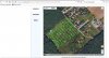
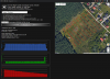
Here is a simple analyzer and viewer of flight logs.
Instruction how to get the log file is on this web page.

In some locations, when you zoom the map enough, you will see 3D preview (but this depends from Google Maps service, mostly in bigger cities).

It is online service. Nothing is installed, just use the below link:


1585319615561.png
 
Last edited:
Wow, nice piece of software.... is this simply for yuneec, or most any machine?
 
HI,

Will this soft work with h520 logs?
Which logs are used to feed the software: the ones from a st16 or those from a bird?

Greetings from Bydgoszcz, Poland,
Pawel
 
Hello, I'm not too sure as I'm not the owner or operator. But it appears to be an extension (of use) possibly for google earth.
The link for this page was provided by JANG.
He was kind enough to provide a link on his post, which is right above the image he uploaded. at the top of this thread.


Go there and use the drop down menu to select the model. I myself see that it is very limited to the Most popular brands.

Reading the directions on the link page, I see there is a need to copy your data file on to the SD card to view on a computer.
Thanx, after I clicked on it, just got the picture ? I guess I was expecting something else, so thank you for clarifying it for me
 
  • Like
Reactions: Mechanic
Hello, I'm not too sure as I'm not the owner or operator. But it appears to be an extension (of use) possibly for google earth.
The link for this page was provided by JANG.
He was kind enough to provide a link on his post, which is right above the image he uploaded. at the top of this thread.


Go there and use the drop down menu to select the model. I myself see that it is very limited to the Most popular brands.

Reading the directions on the link page, I see there is a need to copy your data file on to the SD card to view on a computer.
HI,
I actually visited the link JANG had provided but only after I posted my previous message. Shame on me, but Mechanic thanks for clarifying.
Unfortunately i can hardly see h520 is listed.
 
  • Like
Reactions: Mechanic
you are welcome.

did you tested some h520 log?

HI,
I actually visited the link JANG had provided but only after I posted my previous message. Shame on me, but Mechanic thanks for clarifying.
Unfortunately i can hardly see h520 is listed.
 
I do not know. If you will have problems, send me some of your log file, and I will try to add a fix.


HI,
have not yet tested anything.
BTW - does it make any difference whether I upload logs from st16 or h520 itself?
Pawel
 
BTW - does it make any difference whether I upload logs from st16 or h520 itself?
Both do not work. It is what one can expected because .tlog (ST16) and .ulg (drone) files have a complete different format, not CSV.
All the PX4 stuff will currently not work (H520, Mantis Q/G).

But for the legacy Yuneec telemetry (including Q500, Blade 350QX and Chroma) and Anafi it is a good tool to get an overview. Bardzo dobry. Speed is only available for Typhoon H plus.

br HE
 
Last edited:
Can you send me some sample of tlog ulg ?

Both do not work. It is what one can expected because .tlog (ST16) and .ulg (drone) files have a complete different format, not CSV.
All the PX4 stuff will currently not work (H520, Mantis Q/G).

But for the legacy Yuneec telemetry (including Q500, Blade 350QX and Chroma) and Anafi it is a good tool to get an overview. Bardzo dobry. Speed is only available for Typhoon H plus.

br HE
 
I do not know. If you will have problems, send me some of your log file, and I will try to add a fix.
Hi,

I wish I could.
Could you remind me how to modify .utm file so that I can attach it to a post on this forum?
I used to send logs ones but have apparently completely forgotten how it worked.
Pawel
 
Could you remind me how to modify .utm file so that I can attach it to a post on this forum?
Zip the file/files and add as *.zip file. Zip files are accepted.

Can you send me some sample of tlog ulg ?
Unfortunately not. I do not have a H520. The files I have are from other people. Due to privacy I will not share those files.
But you can look in the forum if you find some...

br HE
 
Last edited:
Zip the file/files and add as *.zip file. Zip files are accepted.

Hi,
here it is.
Hope it works.


FYI - the log represents a test fly done with h520 following terrain. Visualisation of the flight path attached.

br,
Pawel
 

Attachments

  • DroneLogbook-20200328-110730-121.zip
    39.8 KB · Views: 9
  • Flight#1.jpg
    Flight#1.jpg
    154.1 KB · Views: 16
Last edited:
Ahh, I forgot, the utm file also exists at H520. For flight analysis not usable but for that purpose the best choice. Very good idea by @Paw. This is an easy to handle self explaining JSON file that can @JANG easy implement.

br HE
 
Actually, it works with H520 too.

I added battery percentage diagram. It is calculated % between 3.5-4.2V.

1586433258124.png


Hi,
here it is.
Hope it works.


FYI - the log represents a test fly done with h520 following terrain. Visualisation of the flight path attached.

br,
Pawel
 

Attachments

  • 1586432333766.png
    1586432333766.png
    1.3 MB · Views: 9
Last edited:

Members online

Forum statistics

Threads
20,973
Messages
241,792
Members
27,351
Latest member
simsone