


- Joined
- Jun 4, 2017
- Messages
- 513
- Reaction score
- 56
Took the H to a new location next to a large lake. Flew there before with the Q with no problem. I let the bird sit for quite a while but it seemed to have difficulty obtaining more than about 11 Sats on the bird and 9 or 10 on the Transmitter. Moved around in a different location about 50 ft away but never got more than about 12 on the bird and 10 or 11 on controller. Something told me not to fly. Another thing was that when we picked the bird up to move it I would get the warning GPS Lost. Would quickly go away. Another sign to me that maybe I should not fly.
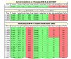
Took the H up to my house and found that I could get 16 Sats on bird and 12 on Trans. Flew it around but felt it was a little herky jerky especially during the landing. So I checked the UAV forecast which I attached and noticed that it did NOT recommend flying. Low Sat reception. How good is the UAV forecast? For tomorrow it has a lot of No FLy in it which looks to be primarily due to cloud cover. How can cloud cover be a problem for Sats. Something was going on today. KP index was less than 5. What do you think.
Took the H up to my house and found that I could get 16 Sats on bird and 12 on Trans. Flew it around but felt it was a little herky jerky especially during the landing. So I checked the UAV forecast which I attached and noticed that it did NOT recommend flying. Low Sat reception. How good is the UAV forecast? For tomorrow it has a lot of No FLy in it which looks to be primarily due to cloud cover. How can cloud cover be a problem for Sats. Something was going on today. KP index was less than 5. What do you think.
Attachments
Last edited by a moderator:


