- Joined
- Dec 23, 2017
- Messages
- 15
- Reaction score
- 0
- Age
- 51
Hi all
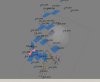
first time using the h520 to do a mapping project at my house
80% overlap with 85ft hgt and standard square with 90 degree ran as well
I have the agisoft demo and load images and align and it comes out not as i would expect..take a look at the screen grab. All the images dont turn up and they are at a bunch of diffrent angles and it has a very hard time making a legible orthomosaic
I suspect a wrong setting during the flight or??
It is the latest firmware on the kit