So I had a quick experiment in 3D mapping this week. It's a relatively easy process, though the software takes a long time to generate the map data. On my machine, 150 images took around 3 hours to be processed.
The steps I used were to plan the mission freehand in UAV Toolbox. The camera estimation tool makes it fairly painless to make sure each run overlaps the next - but yes, I need to write a proper mapping flight planner to make it really easy.
Then flying the mission couldn't be simpler. Put the Typhoon into photo mode, select Timelapse, start the camera capturing photos, then start the Cable Cam mission. It's a little bit of juggling, but everything 'just works', and in this case I got around 300+ photos for the area I was scanning.
The photo processing tools recommend each successive image needs to overlap by around 60%, and you need to be 5-10 times the height of the highest object you're capturing. So I flew at 60 meters, which makes certain I wasn't about to hit any power lines or trees. At the standard cable cam mission speed and 60 meters height, you get many more photos than you need, so I only used every other image to generate the map.
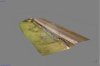
I used Open Drone Map to process the images, though you can use other software such as Pix4D. The Typhoon automatically geotags the images, so all you need to do is upload them and click 'go'. A few hours later you end up with a 2D orthomosaic photo, a 3D point cloud and a 3D textured mesh.
Here are the results:
The steps I used were to plan the mission freehand in UAV Toolbox. The camera estimation tool makes it fairly painless to make sure each run overlaps the next - but yes, I need to write a proper mapping flight planner to make it really easy.
Then flying the mission couldn't be simpler. Put the Typhoon into photo mode, select Timelapse, start the camera capturing photos, then start the Cable Cam mission. It's a little bit of juggling, but everything 'just works', and in this case I got around 300+ photos for the area I was scanning.
The photo processing tools recommend each successive image needs to overlap by around 60%, and you need to be 5-10 times the height of the highest object you're capturing. So I flew at 60 meters, which makes certain I wasn't about to hit any power lines or trees. At the standard cable cam mission speed and 60 meters height, you get many more photos than you need, so I only used every other image to generate the map.
I used Open Drone Map to process the images, though you can use other software such as Pix4D. The Typhoon automatically geotags the images, so all you need to do is upload them and click 'go'. A few hours later you end up with a 2D orthomosaic photo, a 3D point cloud and a 3D textured mesh.
Here are the results: