Hello Fellow Yuneec Pilot!
Join our free Yuneec community and remove this annoying banner!
Sign up

Kamera CGO3+ Neměří výšku. CGO3 + camera Does not measure height.

Joined
Nov 19, 2020
Messages
124
Reaction score
16
Age
82
Kamera nepíše u zachování výšky a Zeměpisná délka. Dříve to na fotce bylo. Je to ve špatném nastavení?
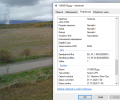
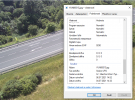
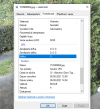
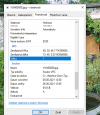
Fotoaparát nepíše nadmořskou výšku a délku obrázku. Dříve to bylo na fotografii. Je to ve špatném nastavení? Jak opravit. Nevím jak je dron vysoko.

The camera does not write at altitude and longitude. Earlier it was in the photo. Is it in the wrong setting?
The camera does not write the altitude and longitude of the picture. Previously it was in the photo. Is it in the wrong setting? How to fix. I don't know how high the drone is.
 
Last edited by a moderator:
Máš příklad? Jaký nástroj používáte ke čtení EXIF dat?

br ON


Do you have an example? What tool do you use to read EXIF data?

br HE

Nevím co to je nástroj EXIF dat. Ale .... Vezmu snímek (obrázek) z kamery, snímek otevřený v PC / Vlastnosti / Podrobnosti. Zde nejsou data Výška.
I don't know what EXIF data tool is. But .... I take a picture (image) from the camera, a picture opened in PC / Properties / Details. There is no Height data.
 

Attachments

  • Foto dříve-Photo before.PNG
    Foto dříve-Photo before.PNG
    394.1 KB · Views: 11
  • Foto nyní-Photo now.PNG
    Foto nyní-Photo now.PNG
    614.6 KB · Views: 10
Nevím co to je nástroj EXIF dat. Ale .... Vezmu snímek (obrázek) z kamery, snímek otevřený v PC / Vlastnosti / Podrobnosti. Zde nejsou data Výška.
I don't know what EXIF data tool is. But .... I take a picture (image) from the camera, a picture opened in PC / Properties / Details. There is no Height data.
First picture has altitde in, second picture was taken without GPS fix. No error seen.
Please remark, that CGO3+ shows reltive altitude (altitude above start position - here 7m) instead of above sea level. This may be irritating, but it is as it is.

EXIF are the metadata that the pictures contain. Windows file manager is one of the tools to display this data, not the best one but OK. If you hav an EXIF tool that cam display the XMP data in the picture you are also able to display the camera direction:
- GPSAltitude (again not GPS altitude but relative to start)
- CameraYaw
- CameraPitch
- CameraRoll

Windows file manager is not able to see that.
 
  • Like
Reactions: DoomMeister
Pochopil jsi špatně. Kamera nepíše výšku !!! Dron je na zemi a kamera napíše 0 m. Dron dám do výšky 15 m a kamera nepíše také 0 m. Na displeji ST16 je výška napsaná. Na fotografii není.
You got it wrong. The camera does not write the height !!! The drone is on the ground and the camera writes 0 m. I will put the drone up to a height of 15 m and the camera also does not write 0 m. The height is written on the ST16 display. Not in the photo.
 
The information is contained in the EXIF data of the photo. Do a web search to find out more information about EXIF data contained in digital images.

The data you see on the ST16 display for altitude is telemetry from the barometric sensor. It does not come from the camera. That barometric reading is contained in the EXIF data of any images saved to the SD card in the CGO3+.
 
Last edited:
Informace jsou obsaženy v EXIF datech fotografie. Chcete -li zjistit další informace o datech EXIF obsažených v digitálních obrázcích, proveďte vyhledávání na webu.

Data, která vidíte na displeji ST16 pro nadmořskou výšku, jsou telemetrie z barometrického senzoru. Nepochází z kamery. Toto barometrické čtení je obsaženo v EXIF datech všech snímků uložených na SD kartu v CGO3+.
Ano rozumím. Já je ale chci na fotografii. Kde je chyba? Druhá kamera výšku napíše. Kde mám hledat chybu?

Yes I understand. But I want them in the photo. Where is the mistake? The second camera writes the altitude. Where should I look for a bug?
 
Last edited by a moderator:
I think I have misunderstood what you are saying. Are are saying you have one camera that records the GPS and altitude data in the EXIF data and another that does not record that data in the EXIF?

If that is the case , then the camera that does not record that data has an issue with the serial data transmission between the aircraft and the camera.


Myslím, že jsem špatně pochopil, co říkáš. Říkáte, že máte jednu kameru, která zaznamenává údaje o GPS a nadmořské výšce v datech EXIF, a druhou, která tato data do EXIF nezaznamenává?

Pokud je tomu tak, pak kamera, která tato data nezaznamenává, má problém se sériovým přenosem dat mezi letadlem a kamerou.
 
Ještě jednou. Vezmu dron, dám kameru aktivuji, letím. Kamera mi dá GPS+ Výška. Vezmu druhou kameru, aktivuji a kamera nedá GPS ani výška. Kde hledat chybu? Zde jsem to dal jen na střechu domu


Once again. I take the drone, I activate the camera, I fly. The camera will give me GPS + Altitude. I take the second camera, activate it and the camera doesn't give GPS or altitude. Where to look for a mistake? Here I only put it on the roof of the house.
 

Attachments

  • GPS + Altitude NO.PNG
    GPS + Altitude NO.PNG
    227 KB · Views: 7
  • GPS + Altitude YES.PNG
    GPS + Altitude YES.PNG
    182.4 KB · Views: 7
The issue has to be inside the camera if you are attaching to the same aircraft. If you have the file WTFDproject.pdf look at Attachment 18. The green wire on the TX pad middle of top row carries the serial data. This connects to the gimbal board via the slip ring assembly, then from the gimbal board to the camera via the UART1 cable. A break in the wiring or a resistive connection can interrupt the data transfer.

Is this a camera that has been in a crash or had other damage of some type?

I know you have threads going for different problems. This one for the camera issues and another for the binding issues with the aircrafts. As I understand it you have a Typhoon H without RealSense with a CGO3+ camera, and another Typhoon H with RealSense with another CGO3+ camera. Both systems have an ST16 for the controller.

Which system has the camera problem?

I also understand you are trying to use the ST16 that holds a charge on the battery to connect to two different aircraft. Is this correct?


Pokud se připojujete ke stejnému letadlu, problém musí být uvnitř kamery. Pokud máte soubor WTFDproject.pdf, podívejte se na přílohu 18. Zelený vodič na TX padu uprostřed horního řádku nese sériová data. To se připojuje k kardanové desce pomocí sestavy kluzného kroužku, poté od kardanové desky k fotoaparátu pomocí kabelu UART1. Přerušení přenosu nebo odporové připojení může přerušit přenos dat.

Je to kamera, která havarovala nebo měla jiné poškození nějakého typu?

Vím, že máte vlákna, která budou řešit různé problémy. Tento pro problémy s kamerou a další pro závazné problémy s letadly. Jak jsem pochopil, máte Typhoon H bez RealSense s kamerou CGO3+ a další Typhoon H s RealSense s další kamerou CGO3+. Oba systémy mají ST16 pro regulátor.

Který systém má problém s kamerou?

Také chápu, že se pokoušíte použít ST16, který drží nabití baterie, ke spojení se dvěma různými letadly. Je to správně?
 
Last edited:
The issue has to be inside the camera if you are attaching to the same aircraft. If you have the file WTFDproject.pdf look at Attachment 18. The green wire on the TX pad middle of top row carries the serial data. This connects to the gimbal board via the slip ring assembly, then from the gimbal board to the camera via the UART1 cable. A break in the wiring or a resistive connection can interrupt the data transfer.

Is this a camera that has been in a crash or had other damage of some type?

I know you have threads going for different problems. This one for the camera issues and another for the binding issues with the aircrafts. As I understand it you have a Typhoon H without RealSense with a CGO3+ camera, and another Typhoon H with RealSense with another CGO3+ camera. Both systems have an ST16 for the controller.

Which system has the camera problem?

I also understand you are trying to use the ST16 that holds a charge on the battery to connect to two different aircraft. Is this correct?


Pokud se připojujete ke stejnému letadlu, problém musí být uvnitř kamery. Pokud máte soubor WTFDproject.pdf, podívejte se na přílohu 18. Zelený vodič na TX padu uprostřed horního řádku nese sériová data. To se připojuje k kardanové desce pomocí sestavy kluzného kroužku, poté od kardanové desky k fotoaparátu pomocí kabelu UART1. Přerušení přenosu nebo odporové připojení může přerušit přenos dat.

Je to kamera, která havarovala nebo měla jiné poškození nějakého typu?

Vím, že máte vlákna, která budou řešit různé problémy. Tento pro problémy s kamerou a další pro závazné problémy s letadly. Jak jsem pochopil, máte Typhoon H bez RealSense s kamerou CGO3+ a další Typhoon H s RealSense s další kamerou CGO3+. Oba systémy mají ST16 pro regulátor.

Který systém má problém s kamerou?

Také chápu, že se pokoušíte použít ST16, který drží nabití baterie, ke spojení se dvěma různými letadly. Je to správně?
Děkuji. Jste vážný odborník.
Mám Váš soubor WTFDproject.pdf v.81. Výborný.
Je to kamera, která havarovala. Já jsem ji opravil. Měla rozbité motory otáčení. Vada bude asi tam jak píšete- zelený vodič. Já jsem toto nekontroloval. Rozeberu to a viz.příloha 18. Děkuji.
A dále. Ano, zjistil jste dobře. MámTyphoon H bez RealSense+ST16 s kamerou CGO3+ (havarovala a nedává data na foto) a také další Typhoon H s RealSense+ST16 kamerou CGO3+. (Typhon H+ST16 bez RealSenze ( od starého drona) . Proč potřebuji oba ST16? Baterie ST16 se dlouho nabíjí a já bych chtěl použít jeden a potom i druhý ST16. Já ale ten druhý ST16 od staršího drona neumím připojit k novému dronu ( není komunikace). Někde psali, že to je spárované již v továrně. Je komunikace s dronem dělána ve fabrice? Nebo jak to udělám já ( jak to nastavit). Nastavit kamery umím, nastavit letadlo (dron) neumím.

Thank you. You are a serious expert. I have your WTFDproject.pdf v.81 file. Excellent. It's a camera that crashed. I fixed it. She had broken rotating engines. The defect will probably be there as you type - green wire. I didn't check this. I will analyze it and see appendix 18. Thank you. And further. Yes, you found out well. I have Typhoon H without RealSense + ST16 with CGO3 + camera (crashed and does not give data for photo) and also another Typhoon H with RealSense + ST16 with CGO3 + camera. (Typhon H + ST16 without RealSenze (from old drone). Why do I need both ST16s? The ST16 battery takes a long time to charge and I would like to use one and then the other ST16. But I can't connect the other ST16 from the older drone to the new drone Somewhere they wrote that it is already paired in the factory Is the communication with the drone done in the factory?
 
  • Like
Reactions: DoomMeister
You can do the pairing yourself by creating a new model and binding to that model. I will try to create a step by step instruction and translate it into Czech for you.

Párování můžete provést sami vytvořením nového modelu a vazbou na tento model. Pokusím se vytvořit návod krok za krokem a přeložit vám ho do češtiny.
 
The document is in great part developed by @WTFDproject who has assisted you in the past.
 
You can do the pairing yourself by creating a new model and binding to that model. I will try to create a step by step instruction and translate it into Czech for you.

Párování můžete provést sami vytvořením nového modelu a vazbou na tento model. Pokusím se vytvořit návod krok za krokem a přeložit vám ho do češtiny.
Ty jsi 1+.

You're 1+.
 
Last edited by a moderator:
Ty jsi 1+.

You're 1+.
See this thread for the guide.

Návod najdete v tomto vlákně.

 
The issue has to be inside the camera if you are attaching to the same aircraft. If you have the file WTFDproject.pdf look at Attachment 18. The green wire on the TX pad middle of top row carries the serial data. This connects to the gimbal board via the slip ring assembly, then from the gimbal board to the camera via the UART1 cable. A break in the wiring or a resistive connection can interrupt the data transfer.

Is this a camera that has been in a crash or had other damage of some type?

I know you have threads going for different problems. This one for the camera issues and another for the binding issues with the aircrafts. As I understand it you have a Typhoon H without RealSense with a CGO3+ camera, and another Typhoon H with RealSense with another CGO3+ camera. Both systems have an ST16 for the controller.

Which system has the camera problem?

I also understand you are trying to use the ST16 that holds a charge on the battery to connect to two different aircraft. Is this correct?


Pokud se připojujete ke stejnému letadlu, problém musí být uvnitř kamery. Pokud máte soubor WTFDproject.pdf, podívejte se na přílohu 18. Zelený vodič na TX padu uprostřed horního řádku nese sériová data. To se připojuje k kardanové desce pomocí sestavy kluzného kroužku, poté od kardanové desky k fotoaparátu pomocí kabelu UART1. Přerušení přenosu nebo odporové připojení může přerušit přenos dat.

Je to kamera, která havarovala nebo měla jiné poškození nějakého typu?

Vím, že máte vlákna, která budou řešit různé problémy. Tento pro problémy s kamerou a další pro závazné problémy s letadly. Jak jsem pochopil, máte Typhoon H bez RealSense s kamerou CGO3+ a další Typhoon H s RealSense s další kamerou CGO3+. Oba systémy mají ST16 pro regulátor.

Který systém má problém s kamerou?

Také chápu, že se pokoušíte použít ST16, který drží nabití baterie, ke spojení se dvěma různými letadly. Je to správně?
Znova (opakovaně) se já vracím k problému Kamera nepíše výšku na foto. Opravil jsem zelený drát a kamera zase nepíše (nedává) výšku. To asi nebyla tato vadaKamera je po havarii, dráty byly utrženy. Opravil jsem je. Kamera dává ( posílá ) výšku + GPS na ST16 ale na foto výška ani GPS není. Kde je závada? Kamera posílá výšku na ST16, ale na foto zde viz Aug 8, 2021 výška není zase napsaná.

Again (repeatedly) I return to the problem The camera does not write the height on the photo. I fixed the green wire and the camera does not write (give) height again. It probably wasn't this defect. The camera is after the crash, the wires were torn off. I fixed them. The camera gives (sends) altitude + GPS to ST16, but there is no GPS or GPS for the photo. Where is the fault? The camera sends the height to ST16, but in the photo here see Aug 8, 2021 the height is not written again.
 
Last edited by a moderator:
Most likely an issue with the camera’s Mainboard. It is most likely not getting the information from the flight controller in the aircraft via the UART communication.
 
If I isolate one of pins (no matter which one) of the serial connection I cannot turn around the camera any more (Gimbal pan mode: Follow controlable and Global mode not possible anymore).
Is it working at your camera which do not write GPS data to EXIF?

br HE
 

Members online

Forum statistics

Threads
20,954
Messages
241,585
Members
27,284
Latest member
csandoval