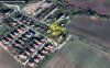
The only file that contains GPS data is "yuneec_2019_09_04_07_09_0.log". I think it is the one, we need. Last recorded position was:

maps.google.com
Begin:
35°34'42.7"N 82°33'01.6"W
home:
35°34'42.8"N 82°33'01.6"W
Check home and start if this was there with the flight in question.
There are a lot of Compass warnings like this:
9221 00:01:35 INFO: '(1,7)geomagnetic field is disturbed '
This is unusual.
Then it got positioning emergency although the GPS is still "3D position":
9998 00:01:38 CRITICAL: 'Failsafe enabled: no local position '
9999 00:01:38 INFO: 'Failsafe mode on '
10143 00:01:39 INFO: '(3,89)ALTCTL MODE '
10144 00:01:39 CRITICAL: 'No valid position, switching to manual mode '
10165 00:01:39 EMERGENCY: 'CRITICAL NAVIGATION FAILURE - CHECK SENSOR CALIBR '
Last horizontal speed was 14m/s which is pretty high. This looks like a classical fly-away.
The KML file, some pictures and the log text is in the attached zip file.
Br HE


")


