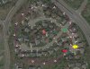
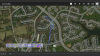
I usually use UAV Toolbox, but today, I used Typhoon H Flight Planner (Flight Planner H - Waypoints Creator for Yuneec Typhoon H) to plan an orbit flight around my neighborhood. The first time I created the flight plan, I kept the direction of the camera pointing to the point of interest in the middle (1) and the flight was without incident. I then edited the flight plan so that the camera was pointing to the next way point. (Attached as "Planned"). My location is depicted as the green diamond. At approximately the red star, the H seemed to drop from the sky! It dropped out of sight and I could not see it anymore and I thought for sure it had crashed! I started running over to the approximate location and while doing so, I switched to RTH. A short time after, as I was heading to the area of the apparent crash, I heard the H flying overhead! (I actually do not know when I hit RTH, but it was certainly way before it shows on the UAV Toolbox actual flight path. Luckily, I did not crash and I was able to land! However, there was still an incident where it went WAY off the planned route. I took a snapshot of the actual flight path from UAV toolbox (Attached as "Actual"). The yellow arrow on the "Planned" pic is about where UAV toolbox shows that it went off course, but again it was more like the location of the red star. Telemetry of the flight is attached as well. Could someone take a look at it and give me an idea as to what might have caused this?
Thanks!
Thanks!