Hello Fellow Yuneec Pilot!
Join our free Yuneec community and remove this annoying banner!
Sign up

Missions!

Joined
Jun 9, 2016
Messages
1,550
Reaction score
1,463
Age
53
Location
UK
A couple of quick questions for those of you who are using the H520 for mapping or photogrammetry, if you could help me?

How often are you flying "new" missions - that is, not reflying a mission you created previously?
When do you tend to create flight plans? On the day in the field, at the office before going out, days in advance?
What sort of jobs are you using missions for? What's missing in the current toolset?
 
Most of my h520 flying is mission jobs. And among them survey missions form great majority of all the jobs. Yet again h520 coupled with Parrot Sequoia is what is flown most of the time.
I always make mission planning while on site as the background maps are not that detailed and always outdated to let me feel comfortable about what is to be flown. This is partly due to the fact that in most cases my targets are smaller that a whole field so I need to walk perimeters to fix the borders of the mission.
I mostly fly new missions and save them to ST16S when I need to re-fly them. I find this option as a handy one.

As a part of me preparing for a mission I check mission site in both Google Earth and desktop/ST16S DataPilot Planner a day or so before.
Having said that I would find it very helpful if ST16S/desktop Planner would provide a search tool for finding locations. As it is today we all need to zoom out and in and scroll the map to find a mission site. This is not very handy. I would prefer to use a search tool and type location's name to have the Planner to display it right away.
 
Hi Pawel. How do you get the Parrot Sequoia to work on the F520? When on site does the GPS on the 16s not show your position on the map when you switch it on?
The reason that I am interested in this is I am thinking of getting a H520 or the newer H520e.
Cheers.
Mike
 
Hi Pawel. How do you get the Parrot Sequoia to work on the F520? When on site does the GPS on the 16s not show your position on the map when you switch it on?
The reason that I am interested in this is I am thinking of getting a H520 or the newer H520e.
Cheers.
Mike
Hi,
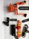
SQ works completely separately from h520. There is no integration of it to the DataPilot at all. H520 is only a carrier. Telemetry comes from e90 so I can see h520+SQ position on the ST16S.
SQ is powered from a powerbank which is attached to the front arms of the h520 whilest the SQ is mounted on the back ones. The SQ triggering is set via its wifi interface and I use an iPad/laptop to do it.
 

Attachments

  • IMG_20191014_183440.jpg
    IMG_20191014_183440.jpg
    1 MB · Views: 18
  • Screenshot_20191126_170326.jpg
    Screenshot_20191126_170326.jpg
    253.6 KB · Views: 19
Hi,
SQ works completely separately from h520. There is no integration of it to the DataPilot at all. H520 is only a carrier. Telemetry comes from e90 so I can see h520+SQ position on the ST16S.
SQ is powered from a powerbank which is attached to the front arms of the h520 whilest the SQ is mounted on the back ones. The SQ triggering is set via its wifi interface and I use an iPad/laptop to do it.
That's a very nice setup you have there. Was it purpace made by you or is it commercially available. I'd say it hurts your flight times with the extra weight?
Cheers.
Mike
 
That's a very nice setup you have there. Was it purpace made by you or is it commercially available. I'd say it hurts your flight times with the extra weight?
Cheers.
Mike
Hi,

Total additional weight of the setup incl. power bank, camera and sunshine sensor is around 500g. I normally can get app. 15-17 minutes in the air compared to 18-19 without the SQ depending on wind.
I bought this kit which is a 3d print.
 
  • Like
Reactions: Mike Irish

New Posts

Members online

Forum statistics

Threads
20,955
Messages
241,599
Members
27,284
Latest member
csandoval