Hello Fellow Yuneec Pilot!
Join our free Yuneec community and remove this annoying banner!
Sign up

Need help to send flight log to forum for analysis

Joined
Jul 14, 2020
Messages
43
Reaction score
13
Age
68
Hello All Yuneec Pilots~
I have been flying several Typhoon H drones and have unfortunately had one fly away and another recently crashed. I have successfully flown both drones over a hundred times and usually have no problems. I finally decided to ask for help to figure out what went wrong. I have carefully reviewed the WTFD Project and have tried to follow the instructions, but am running into roadblocks.

I tried both methods (sd card & USB Cable to laptop). I inserted a new AD Card in bottom of Tx as directed. I then was able to download the file and also was able to create the zip file. When I try to copy the zip file to the SD card I am only able to find "internal storage". How do I select SD card as destination?

I also tried to save the file to my laptop without success. Should I be using the same cable that is used to charge the ST16? That is what I did, but when I look at the File menu U cannot find the ST16. I understand that it may have an unusual name, but still cannot find it.

Any suggestions would be much appreciated!! Dave
Update to my recent post...Tried a different SD Card and I think I got it to work. I had to take an extra step not listed in WTFD Project instructions. On the ST16, I went to settings and then to storage. There was an option to "mount" the sd card so I did that. I then saw both SD & internal storage options in top left corner of screen.

I am attaching 2 different flight logs; I have 2 ST16 controllers and have used both for several TH's I have owned. One is labeled FlightLogA & the other is FlightLogB. If anyone is able to make any sense of what happened that caused one to fly away and another to crash I would greatly appreciate your analysis. In all cases I did a calibration of compass and I also made sure I had plenty of battery left on drone and ST16 before taking flight. Thanks in advance for your help !!
 

Attachments

  • FlightLogA.zip
    16.3 MB · Views: 4
  • FlightLogB.zip
    17.4 MB · Views: 7
Hello All Yuneec Pilots~
I have been flying several Typhoon H drones and have unfortunately had one fly away and another recently crashed. I have successfully flown both drones over a hundred times and usually have no problems. I finally decided to ask for help to figure out what went wrong. I have carefully reviewed the WTFD Project and have tried to follow the instructions, but am running into roadblocks.

I tried both methods (sd card & USB Cable to laptop). I inserted a new AD Card in bottom of Tx as directed. I then was able to download the file and also was able to create the zip file. When I try to copy the zip file to the SD card I am only able to find "internal storage". How do I select SD card as destination?

I also tried to save the file to my laptop without success. Should I be using the same cable that is used to charge the ST16? That is what I did, but when I look at the File menu U cannot find the ST16. I understand that it may have an unusual name, but still cannot find it.

Any suggestions would be much appreciated!! Dave
A couple of things:
1.) Which file is associated with the flyaway and which is associated with the crash?
2.) Are both flightlog files from the same controller?
(Yeah, pretty sure they are not, but thought I would ask anyway.)
3.) The flightlog dates are messed up. (At least when viewed on my PC.) Did you open the files with any other program (such as Excell) before uploading to the forum? Some individual flights are missing from the file log sets.

You mentioned a problem getting the SD cards to "mount". I believe that is supposed to be an automatic process. Did you have to manually mount on BOTH controllers?

Please give us your best guess at which flight number is associated with each of the two events. Anything you can remember, such as the location of the flights, would help.
 
Last edited:
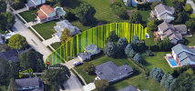
I guess B is the crash. I have removed all datasets from year 2014. Remains the second flight which leads into a crash, motor 6 (front right) blocked. This happens in ~10m height during RTH near the tree. The big question: Why is the RTH altitude so low? It should climb instead to accelerate. It was not yet in landing mode. The flight track shows, that RTH was not done. Some Compass errors at this but only for 1 sec.
track_B.png
No idea what made the drone to flee...

br HE
 
A couple of things:
1.) Which file is associated with the flyaway and which is associated with the crash?
2.) Are both flightlog files from the same controller?
(Yeah, pretty sure they are not, but thought I would ask anyway.)
3.) The flightlog dates are messed up. (At least when viewed on my PC.) Did you open the files with any other program (such as Excell) before uploading to the forum? Some individual flights are missing from the file log sets.

You mentioned a problem getting the SD cards to "mount". I believe that is supposed to be an automatic process. Did you have to manually mount on BOTH controllers?

Please give us your best guess at which flight number is associated with each of the two events. Anything you can remember, such as the location of the flights, would help.
First of all, thanks for your time & help in figuring out what happened. I bought my first TH about 6 years ago & I was not aware of the flight logs at that time. My first flyaway happened about 4 years ago & before I discovered this forum. I probably deleted some of the logs while trying to figure out the problem. I have 2 ST16's and have used both for all of the 3 TH's I have owned. I do not think I ever tried to open with any other program like Excel because I would not understand how to interpret the results.
As far as the "mounting" of the SD card...I think I only needed to do that on one of the ST16's, but not sure now of which one. Both the flyaway and the crash originated from my backyard which is near the screenshot you sent. I am pretty sure the crash which happened about a month ago was from the flightlog "A". The crashed drone was bought used on ebay to replace the flyaway. It flew OK at times, but would sometimes drift while hovering. I made sure the drone was properly calibrated and also checked the monitor that showed all sticks and other controls were centered and looked good. Since I was not comfortable with the performance, I did not have a camera attached when it crashed. I took off from my backyard and elevated to about 75 feet. I stopped there to see if it would hover properly, but it was drifting sideways. When I tried to correct with sticks, it would not respond and started to flyaway. At that point I hit RTH, but no response. The drone flew over the house behind me and nose-dived into the concrete street. It wasn't far away and I heard the crash. Fortunate that it did not damage anything but itself. It hit so hard that I broke the main internal frame and the battery broke out of it's casing. Glad no camera was involved!
 
What size are the SD cards you are using in the ST16? The largest it can use is a 32GB card formatted FAT32. The Android OS used in the tablet is old and not capable of reading larger cards.

I’ll try to take a look at the logs over the next few days.
 
What size are the SD cards you are using in the ST16? The largest it can use is a 32GB card formatted FAT32. The Android OS used in the tablet is old and not capable of reading larger cards.

I’ll try to take a look at the logs over the next few days.
I am using a 32gb card. I think that I was able to correctly download the flight logs that were stored, but I do not see any date that matches when the last crash occurred about a month ago.
 
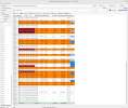
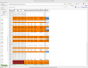
Maybe it helps to identify affected flights when I send the last part of the flight listings for set A and set B.
A.pngB.png
Remarks:
- orange marked flight: Compass calibration errors occurred
- maroon means Emergency (motor stops) occurred
- in column Umin voltage warnings 1 and 2 are marked in lighter or (2) in darker blue (avoid to fly down to Voltage warning 2)
- in set B the last two rows shows cut-off from flightlog number 00353 made for deeper analysis
- empty rows are flightlogs without takeoff (no in-air flight modes)

br HE
 
I guess B is the crash. I have removed all datasets from year 2014. Remains the second flight which leads into a crash, motor 6 (front right) blocked. This happens in ~10m height during RTH near the tree. The big question: Why is the RTH altitude so low? It should climb instead to accelerate. It was not yet in landing mode. The flight track shows, that RTH was not done. Some Compass errors at this but only for 1 sec.
View attachment 28797
No idea what made the drone to flee...

br HE
This flight is likely the flyaway I mentioned. I did have a camera on during flyaway, but no camera when I had crash about a month ago.
 
After more study I do think the flight with the aerial pictures is the one that flew away. I don't think it crashed there because I could see it fly further away, and it was going fast! Never found it despite having my FAA Number on it along with my phone number and a note offering a reward.

Looking like I will not find out why drone #2 crashed a month ago. Not a huge deal since that drone was nearly a total loss. Not many salvagable parts. Thanks again for your help!
 
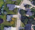
If you mean the GoogleEarth flight track from #6 then the drone could be located. I have created the kml file with 'clamp to ground' that means it is projected to surface of the earth. It hits the tree in 7,95m height and gone down relatively fast to 3.35m. For me this looks like it is hanging in the tree there. You can 'play' the kml file in GoogleEarth. You will see the drone strikes a hook at the very end. I think it comes from struggeling with the branches.
trackB_clamp to ground.png
br HE
 

Attachments

  • Telemetry00353.zip
    7.6 KB · Views: 2
I believe that is the crash from a month ago. I did recover that drone, but it hit the concrete hard and was destroyed.
Question: I did not have a camera attached during this flight, so are the pictures from a combination of Google Earth & TH telemetry?
 
Yes the flight was without camera. When camera is connected you will see a lot of datasets with RSSI=0. This is when the cam sends telemetry. When telemetry comes via 2.4GHz ZigBee connection then RSSI will be provided. That means, easy to see if camera was connected or not.

The KML files was made from telemetry data using q500log2kml tool.

br HE
 

New Posts

Members online

No members online now.

Forum statistics

Threads
20,952
Messages
241,578
Members
27,284
Latest member
csandoval