Hello Fellow Yuneec Pilot!
Join our free Yuneec community and remove this annoying banner!
Sign up

planned in-flight crash

Joined
Jul 15, 2021
Messages
35
Reaction score
22
Age
68
Location
France (Nord)
I am on a height, I take off the drone, perform a few movements and then I launch the mission. The drone leaves for the first waypoint (programmed to take a photo at 20m altitude) suddenly it goes down, I no longer see it (far - 200m - and behind the trees) and I do not have time to "catch up". I find it in the grass and the camera is out of order.
15 minutes before, I made a short flight and also planned on another place lower down.
Is it possible that the drone does not register its new position and would have remained at a starting altitude corresponding to the previous mission?
Note that the crash mission is a recurring mission (therefore known and recorded location altitude) already carried out several times, only a few minor modifications downloaded before the flight.
But why would he have gone to a level below the ground when the altitude of the waypoint is 20m and he had to record the altitude to land?
Or, what other problem could he have had?
Have you had such a situation?
Thank you for your opinion
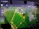
(photo mission and crash site)
 

Attachments

  • lieu du crash.jpg
    lieu du crash.jpg
    2 MB · Views: 43
Ich bin auf einer Höhe, hebe die Drohne ab, führe ein paar Bewegungen aus und dann starte ich die Mission. Die Drohne fährt zum ersten Wegpunkt (programmiert um ein Foto in 20m Höhe zu machen) plötzlich geht es runter, ich sehe es nicht mehr (weit - 200m - und hinter den Bäumen) und ich habe keine Zeit zum "aufholen". Ich finde es im Gras und die Kamera ist außer Betrieb.
15 Minuten vorher habe ich noch einen kurzen Flug gemacht und auch einen anderen Platz weiter unten geplant.
Kann es sein, dass die Drohne ihre neue Position nicht registriert und auf einer der vorherigen Mission entsprechenden Starthöhe geblieben wäre?
Beachten Sie, dass es sich bei der Crash-Mission um eine wiederkehrende Mission (daher bekannte und aufgezeichnete Standorthöhe) handelt, die bereits mehrmals durchgeführt wurde und nur wenige geringfügige Änderungen vor dem Flug heruntergeladen wurden.
Aber warum sollte er auf eine Ebene unter der Erde gehen, wenn die Höhe des Wegpunkts 20 m beträgt und er die Höhe zur Landung aufzeichnen musste?
Oder welches andere Problem könnte er gehabt haben?
Hatten Sie eine solche Situation?
Danke für deine Meinung
(Fotomission und Absturzstelle)
m in Deutschen Foren ist es öfters zu lesen das der 520 öffters mal so vom Himmel fällt... ich vermute das die Akkus nen fehler haben und einfach auf 0 gehen ... von der Programmierung wohl er nicht ... m in German forums you can often read that the 520 often falls from the sky ... I suspect that the batteries have faults and simply go to 0 ... from the programming probably not ...
 
The fall does not seem brutal enough to me to be due to a cut but maybe ...
I sent the telemetry to YUNEEC. I await the return.
 
No response from Yuneec, disappointing.
The drone flies again without problems with the E90.
I still believe there was a st16s / CGO ET link fault.
I had to fix a landing gear. For info which can be useful to Europeans: very good service from YUNNEC SKIN, part ordered on 26/09 received on 07/10. It cost me 90 € including transport and bank charges. But still with a little "surprise" from French customs on arrival !!
 

Attachments

  • taxe envoi.jpg
    taxe envoi.jpg
    1.7 MB · Views: 11
  • Wow
Reactions: 7cyclops
No response from Yuneec, disappointing.
The drone flies again without problems with the E90.
I still believe there was a st16s / CGO ET link fault.
I had to fix a landing gear. For info which can be useful to Europeans: very good service from YUNNEC SKIN, part ordered on 26/09 received on 07/10. It cost me 90 € including transport and bank charges. But still with a little "surprise" from French customs on arrival !!
The "surprise" is not a surprise....
In Europe, all imported goods exceeding 22 euros in value are subject to custom checks...and taxes.... but it is so from many years.
Regarding your problem, could it be a faulty connection on the battery?
See also this thread: battery meltdown round 2
 
Yes, my "surprise" remark was meant to be sarcastic.
For the battery problem I remain reserved. The start of the fall was regular, not brutal (afterwards, behind the trees, I didn't see).
But thank you very much for the thread, really interesting.
Now I am going to be very much more attentive to my batteries which, to this day, do not present any visible defect on the outside.
 
  • Like
Reactions: Pier2162
I am having first gen h520 battery connector installed the second gen h520e. waiting on flight test results from the repair shop.
 
Yes, this confirms the thread's comments. I have an H520, I am reassured but I retain 3 things from this thread:
1. do not unnecessarily tire the batteries (do not say to yourself: oh my battery is only 50% discharged, I will take a few more images to use what I have left)?
2. remove the battery from the aircraft upon landing?
3. always check its temperature?
Some of these metrics are certainly written in the owner's manuals (or even elsewhere on this site) but it's more alive to remember that from a thread.
 
Among the various things to do in order not to damage the batteries, I would add not to recharge them when they are hot.
It is also a good practice to remove them from the drone immediately after landing, to allow them to cool down and avoid IMU overheating.
@FR MD PHB : Are batteries new?
 
Yes, each of the 2 batteries must not last more than 5 hours of flight. Complete flight with no problem with one of them when I put the E90 back on; I will do a test flight again with the other battery without moving the device too far from the starting point and without taking any risks. I can no longer say which of the two was used during the crash.
 
As expected, the drone flew well this morning with the second battery.
For telemetry, it is beyond my skills. And sending the files to https://yuneec.kayako.com/en/ is a failure.
Extensions like (example: .sky) are not accepted anywhere. If anyone can tell me how to read them or transform them, that would help me.
 
This video is how to download the ulg files (ulog) for the H520 and H Plus.


You can then upload the applicable ulog file to Flight Review and share the link here so we can go look at the results.
 
  • Like
Reactions: FR MD PHB
thank you.
small precision for the video on qground, the tab es folder is not any more immediately in the top bar, it is necessary to click on the Q to open a window or "analyze tools" appears.
the URL of the downloaded file is:


New Posts

Members online

Forum statistics

Threads
20,955
Messages
241,587
Members
27,284
Latest member
csandoval