Hello Fellow Yuneec Pilot!
Join our free Yuneec community and remove this annoying banner!
Sign up

MAJOR help needed - lost drone

Joined
Apr 14, 2021
Messages
17
Reaction score
3
Age
48
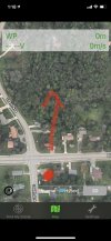
So I FINALLY got my drone ready for fun. After the battery issues last month, then breaking 7 out of 8 propellers and waiting for them to come in(2 weeks), then landing in the hospital for almost a week....I got the blades changed last night. My grandson and I brought it outside this morning, launched it....and I instantly had no control over it....it just kept climbing...then headed North of my house. Is there ANY chance I can get the coordinates of where it landed off the app? I found the flight log, just not the gps. Any help is appreciated. I spent over an hour in a pretty heavily wooded area where it went down, and spent a lot of time looking up into the tree tops as well....didn’t find it. Any ideas?
 

If you were using the virtual sticks on the phone then there may be enough information in the log file to come up with a location.
 
I appreciate it. I got to step 6, but it wouldn’t let me save as a file. Just kept trying to open a folder, which didn’t work. I’ll get on it again at work tomorrow and see what I can accomplish.
 
At step 6 you are saving the entire folder so it will not save as a file.
 
If you find you may want to attach a tracking device (I have used Trackimo for past 6 years on all flights). AT least you have a
chance since the tracking device battery will normally last a few days. I have had two flyaways with DJI never found and in
each case I forgot to put the tracker on. Good luck.
 
  • Like
Reactions: Nesher and Vampyre9
Here's the actual flight(I think) where it took off. Plus a zip of the entire log. Anything else I can do?
 

Attachments

  • FlightLog05022021.png
    FlightLog05022021.png
    431 KB · Views: 11
Here's the actual flight(I think) where it took off. Plus a zip of the entire log. Anything else I can do?
If that is the actual flight, you used Pilot mode without GPS (mode 10) and there seems to be a problem with the barometric altimeter. After liftoff it went to a height of 56 feet then abruptly went to negative altitude values.

We really need the zipped folder of the FlightLog without any other program opening the files.
 
It's not letting me upload it? Says it's not valid...but I zipped with with WinRar. I'll try again.
Change the .rar to .zip
 
Here’s a pic of the area as well. The red dot is where it was launched, and it ended up somewhere around the red arrow.
 

Attachments

  • D047CC5E-9131-4E90-86C7-A6B987BDFFFD.jpeg
    D047CC5E-9131-4E90-86C7-A6B987BDFFFD.jpeg
    2.3 MB · Views: 17
The last flight that I see in the logs is very short, only 30s. It shows Take-off and landing. Flight was without GPS.
2021-05-02 10:02:0112610131320328262432801312-117602239428274008-86038781018-16891150-53915011160
.
landing.jpg

I guess that is not the flight with the fly away.

All your log files are very small. This is unusual. I don't know if this is a problem with your i-phone.
 
The last entry shows Pilot mode without GPS, possibly because there are only 8 or 9 satellites and the Breeze needs 11. The flight was around 10 AM and the weather was about 70 degrees with strong winds of 25 mph from the SW with gusts to 36 mph. The altimeter is definitely showing weirdness. I was off in my first post about the altitude and after reviewing notes on the altitude column the max height in the telemetry is 0.56 feet and the altimeter then starts recording negative altitude. From 10:01:40 to 10:02:01 the altitude went from -1.5 feet to -1176 feet. This may explain you seeing it continue to ascend without control. The Breeze expects to launch and hover at the height set in the drone settings menu which in this case is 3.2 feet (1 meter). I do see a change in Flight mode for the last two entries in the log (mode 18) which is the landing mode. This is indicative of a Breeze with a dirty IRS Sensor filter or a faulty IRS sensor (this is prone to bad solder joints where it is attached to the M7 board when the drone is crashed). In this case the drone ascends without user control trying to get to the takeoff height setting. Since the altitude is off with the IRS sensor it keeps ascending for about 20 seconds then goes to landing mode. It is hard to say what the actual height it got to before going to Landing mode.

I will plot the course manually in Google Earth Pro and upload in a little while.
 
Here is the plot in Google Earth Pro. I would conduct the search along that path realizing that once connection is lost the Breeze will hover then start back toward its launch position. The strong SW winds may affect the path of flight since GPS was disabled.
Breeze flight path.jpg
 
I was reviewing the operating sequences for the Breeze and the first 5 meters of altitude (~16 feet) is measured by the IRS sensor and that is what the takeoff function is using for altitude control. When it does not see the altitude increasing more power is added to the motors. With your telemetry showing s rapid decrease in altitude it would have commanded more and more power until the 20 second time frame had passed and the landing mode being automatically initiated.

I truly believe this may have been an instance of bad solder connections from the previous crash that destroyed props.

If you recover the aircraft let us know. You can check using this document https://yuneecpilots.com/attachments/breeze-disassembly-guide-pdf.24138/
 
Thank you all so much. I’m heading out tomorrow on my day off to find it. My wife is pretty mad that I just lost $200 so if I don’t want to sleep on the couch, I’ll find it!
 
It never got GPS lock. You are too close to the building which prevents GPS from receiving proper signals.
The few data recorded in the log are not enough to give a good indication where it gone.
@DoomMeister has made the best approximation that is possible.

This was the last recorded location:
Last_recorded_location.jpg

I would ask in the neighborhood or look into the trees behind this house.

br HE
 

Attachments

  • #2021_05_02_10_00_53.zip
    1.2 KB · Views: 2
Last edited:
Offtopic @DoomMeister:

I have removed the limitation to create a KML file for Breeze only if a GPS Lock was detected. Now the KML files will also appear when GPS lock never took part.
Download only from my homepage - all other location not updated yet.

br HE
 
Thanks Helmut!
 

New Posts

Members online

No members online now.

Forum statistics

Threads
20,955
Messages
241,587
Members
27,284
Latest member
csandoval