We have just purchased a H520 with E90 camera. We will mostly be using this for survey missions and creating 3D models in Pix4D. Most sites we fly are quarries, and landfill sites, so large open areas. I have lots of fixed wing experience but this is the first multi copter I have flown so this is opening up a whole lot of new opportunities.
First impressions are that it is a great flying platform and very easy to control so we are really happy with that.
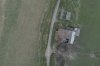
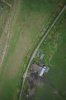
However the images that we have captured in our trials are very washed out and appear like a winters day - blue / grey. We can improve the orthomosaic image in Photoshop to make the colours more vibrant and realistic. But I don't really want to this for every project as we are limited on file size and the geotag information can be lost.
What camera settings do people recommend for surveys?
What speed are people flying survey missions at? We have tried 5m/s and 10m/s and both provide crisp images so hopefully we can stick with 10m/s?
Can anybody confirm the fail safes? I've read plenty of horror stories about low battery warnings, but is that still the case on the latest version of DataPilot 1.3? Whats the time for a lost link between the ST16 and H520 before it returns home?
Thanks for any pointers. Ive asked Yuneec for help but maybe this forum will react quicker? We will do more testing tomorrow.
Ed
First impressions are that it is a great flying platform and very easy to control so we are really happy with that.
However the images that we have captured in our trials are very washed out and appear like a winters day - blue / grey. We can improve the orthomosaic image in Photoshop to make the colours more vibrant and realistic. But I don't really want to this for every project as we are limited on file size and the geotag information can be lost.
What camera settings do people recommend for surveys?
What speed are people flying survey missions at? We have tried 5m/s and 10m/s and both provide crisp images so hopefully we can stick with 10m/s?
Can anybody confirm the fail safes? I've read plenty of horror stories about low battery warnings, but is that still the case on the latest version of DataPilot 1.3? Whats the time for a lost link between the ST16 and H520 before it returns home?
Thanks for any pointers. Ive asked Yuneec for help but maybe this forum will react quicker? We will do more testing tomorrow.
Ed

")