

- Joined
- Oct 15, 2016
- Messages
- 10
- Reaction score
- 4
- Age
- 67
Went flying this afternoon and my THP performed flawlessly. This evening I logged on to Dronelogbook,com to upload my flights and something weird happened. The first attached file is a screenshot of how the Dronelogbook algorithm interpreted my telemetry file. Everything looks as it should with the exception of that line going off to the 8:00 position.
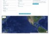
The second attachment is a zoomed out version of the same map. While I'm pleased with the distance traveled (didn't know that either my battery or my ST16 had that kind of range) and max altitude shown here, the accuracy leaves a little something to be desired. The flight date, duration, and maximum speed all seem to match what I flew.
Any ideas would be most appreciated.
") LOL What batteries are you using????
LOL What batteries are you using????")