Hello Fellow Yuneec Pilot!
Join our free Yuneec community and remove this annoying banner!
Sign up

trying to understand a strange bebaviour today

Joined
Mar 16, 2021
Messages
23
Reaction score
1
I thought i'd try out the advice on i got earlier on turning the Breeze slowly (Yaw).. using very slight movement in the middle of the area on my phone.
I'm amazed at how slowly you can turn it now.. Brilliant!

This was all about 4ft in the air.. didn't wart to go above our fence height as it was a little to breezy.. Then the Breeze rose up.. me pressing the wrong direction... Then the wind got it wafting away from me.. I tried desperately, pressing the return to home button after which it disappeared over my fence out of sight... ... I ran out of the house to the other side which is pavement/road... And it hand landed in the middle of the road; intact.

I don't mind saying it gave me a right kick up the rear into reality.

I didn't have the forethought to check my settings on the app... and now wondering if i hadn't set GPS mode. The drone didn't seems as stable as it had been in the day previously.. despite the breeze.

Any thoughts on this behaviour? I don't know enough to guess.
 
If you are near buildings and trees the GPS can be off due to reflected signals. If you previously flew from the street side of your house it may have thought that was the RTH position. If you had GPS disabled it would not be able to perform an RTH because no home position would have been recorded at takeoff. Here is where you turn GPS on and off. Default is on.
D6007604-6BFC-47F2-9631-5C790AFA67F5.jpeg
 
If you are near buildings and trees the GPS can be off due to reflected signals. If you previously flew from the street side of your house it may have thought that was the RTH position. If you had GPS disabled it would not be able to perform an RTH because no home position would have been recorded at takeoff. Here is where you turn GPS on and off. Default is on.
View attachment 25209
GPS signals aren't vulnerable to reflections like other radio radiations.
 
So they are not absorbed by obstacles nor reflected off of buildings or metal structures?
 
So they are not absorbed by obstacles nor reflected off of buildings or metal structures?
They might be absorbed yes. You said that the signal 'can be off due to reflection' and that can't happen.
The GPS signal is pure data, it's direction or reflections are of no consequence. It's a simplification, but the GPS signal carries the identifier of the satellite that sent it, it's position and the time it was sent. The receiver uses those to work out where it is in relation to the satellite. It then does the same with as many satellites as it can see. In short, the direction of received GPS data is irrelevant, only how long it took to get there.
 
Trying again - this is the .log text.. can't attach the .log

YC
StartTime:2021-03-20 05:01:07
Platform:Android28
Location:
FC:10000,ESC:10003,Camera:10000,App:83
DroneSN:YU16390FBEB09A01
HardwareInitStatus:0

UTC,TimeStamp,flightMode,distance,height,loseGPSAct,goHomeHeight,maxHeight,maxDistance,maxSpeed,alt,IMU_Sta,lat,lon,AutoTakeOFF,roll,pitch,yaw,motorStatus,errorFlags,nsat,voltage
2021-03-20 05:01:08,48,0,40,20,1,300,800,959,500,-20,-81,525186527,-18436982,0,-5531,-128,61,15,0,-113,198
2021-03-20 05:01:09,49,0,40,20,1,300,800,959,500,-26,-81,525186411,-18437077,0,-6679,-109,2306,15,0,-113,198
2021-03-20 05:01:10,50,3,40,20,1,300,800,959,500,-29,-17,525186303,-18437161,0,-11242,-2638,5698,15,0,-113,196
2021-03-20 05:01:11,51,3,40,20,1,300,800,959,500,-18,-1,525186209,-18437237,0,-10374,-2944,4350,15,0,-114,197
2021-03-20 05:01:12,52,3,40,20,1,300,800,959,500,-4,-17,525186145,-18437233,0,-5333,-1191,-326,15,0,-113,197
2021-03-20 05:01:13,53,3,40,20,1,300,800,959,500,2,-17,525186024,-18437248,0,-997,1109,4797,15,0,-113,198
2021-03-20 05:01:14,55,3,40,20,1,300,800,959,500,-3,-17,525185872,-18437225,0,-1200,1050,5315,15,0,-113,197
2021-03-20 05:01:15,56,0,40,20,1,300,800,959,500,-6,-81,525185716,-18437251,0,-709,632,6225,15,0,-116,198
2021-03-20 05:01:16,57,0,40,20,1,300,800,959,500,-8,-81,525185563,-18437269,0,-312,114,5765,15,0,-113,197
2021-03-20 05:01:17,58,0,40,20,1,300,800,959,500,-6,-81,525185394,-18437273,0,876,191,5109,15,0,-113,197
2021-03-20 05:01:18,59,0,40,20,1,300,800,959,500,-6,-81,525185267,-18437325,0,-413,397,4631,15,0,-113,198
2021-03-20 05:01:19,60,0,40,20,1,300,800,959,500,-4,-81,525185143,-18437390,0,-552,375,4550,15,0,-112,198
2021-03-20 05:01:20,61,0,40,20,1,300,800,959,500,-9,-81,525185023,-18437436,0,-749,673,4281,15,0,-113,198
2021-03-20 05:01:22,62,0,40,20,1,300,800,959,500,-10,-81,525184866,-18437496,0,-1595,931,3972,15,0,-113,198
2021-03-20 05:01:23,63,0,40,20,1,300,800,959,500,-9,-81,525184700,-18437530,0,198,-1300,5889,15,0,-114,196
2021-03-20 05:01:24,64,0,40,20,1,300,800,959,500,-9,-81,525184529,-18437573,0,-569,-1325,5427,15,0,-114,197
2021-03-20 05:01:25,65,0,40,20,1,300,800,959,500,-11,-81,525184378,-18437612,0,-24,-1116,5289,15,0,-114,198
2021-03-20 05:01:26,66,0,40,20,1,300,800,959,500,-12,-81,525184231,-18437622,0,255,-1290,5100,15,0,-112,198
2021-03-20 05:01:27,67,0,40,20,1,300,800,959,500,-9,-81,525184097,-18437627,0,-2496,-3037,6867,15,0,-112,197
2021-03-20 05:01:28,68,0,40,20,1,300,800,959,500,-14,-81,525183950,-18437683,0,-2191,78,1007,15,0,-112,197
2021-03-20 05:01:29,69,3,40,20,1,300,800,959,500,-12,-17,525183786,-18437748,0,-4410,91,-113,15,0,-112,199
2021-03-20 05:01:30,70,3,40,20,1,300,800,959,500,-5,-17,525183655,-18437705,0,-4971,-1321,-4650,15,0,-113,198
2021-03-20 05:01:31,71,3,40,20,1,300,800,959,500,0,-17,525183552,-18437582,0,-2856,-3894,-8360,15,0,-113,198
2021-03-20 05:01:32,72,3,40,20,1,300,800,959,500,-5,-17,525183478,-18437415,0,-4159,-3776,-8090,15,0,-113,198
2021-03-20 05:01:33,73,3,40,20,1,300,800,959,500,-10,-17,525183410,-18437260,0,-4769,-5357,-8957,15,0,-112,198
2021-03-20 05:01:34,74,3,40,20,1,300,800,959,500,-8,-17,525183353,-18437075,0,-4964,-3116,-9780,15,0,-112,197
2021-03-20 05:01:35,75,3,40,20,1,300,800,959,500,-3,-17,525183315,-18436881,0,-4936,-1458,-12510,15,0,-112,198
2021-03-20 05:01:36,76,3,40,20,1,300,800,959,500,2,-17,525183391,-18436742,0,-3201,-1607,-15586,15,0,-111,198
2021-03-20 05:01:37,77,3,40,20,1,300,800,959,500,-3,-17,525183535,-18436667,0,-2307,-441,14708,15,0,-110,198
2021-03-20 05:01:38,78,3,40,20,1,300,800,959,500,-9,-17,525183663,-18436615,0,-4311,594,11091,15,0,-110,198
2021-03-20 05:01:39,79,3,40,20,1,300,800,959,500,-6,-17,525183791,-18436563,0,-4572,750,9877,15,0,-110,198
2021-03-20 05:01:40,80,3,40,20,1,300,800,959,500,-17,-17,525183887,-18436522,0,-6366,1420,8347,15,0,-111,198
2021-03-20 05:01:41,81,0,40,20,1,300,800,959,500,-28,-81,525183900,-18436514,0,-6582,1246,10393,15,0,-113,199
2021-03-20 05:01:42,82,0,40,20,1,300,800,959,500,-27,-81,525183923,-18436519,0,-5694,497,10574,15,0,-112,197
2021-03-20 05:01:43,83,0,40,20,1,300,800,959,500,-1,-81,525183978,-18436553,0,-5495,-930,16234,15,0,-111,197
2021-03-20 05:01:44,84,0,40,20,1,300,800,959,500,-10,-81,525183987,-18436566,0,-6036,-567,-15730,15,0,-112,198
2021-03-20 05:01:45,85,0,40,20,1,300,800,959,500,-14,-81,525183939,-18436568,0,-3443,61,-16828,15,0,-112,197
2021-03-20 05:01:46,86,0,40,20,1,300,800,959,500,-24,-81,525183902,-18436567,0,-4941,-785,15488,15,0,-110,198
2021-03-20 05:01:47,87,0,40,20,1,300,800,959,500,-34,-81,525183879,-18436590,0,-5662,-1999,13279,15,0,-112,198
2021-03-20 05:01:48,89,0,40,20,1,300,800,959,500,-43,-81,525183784,-18436562,0,-8674,443,9474,15,0,-115,195
 
They might be absorbed yes. You said that the signal 'can be off due to reflection' and that can't happen.
The GPS signal is pure data, it's direction or reflections are of no consequence. It's a simplification, but the GPS signal carries the identifier of the satellite that sent it, it's position and the time it was sent. The receiver uses those to work out where it is in relation to the satellite. It then does the same with as many satellites as it can see. In short, the direction of received GPS data is irrelevant, only how long it took to get there.
Direct page from the source quoted by @h-elsner for multi path signals that induce error Multipath | GEOG 862: GPS and GNSS for Geospatial Professionals
 
Trying again - this is the .log text.. can't attach the .log

YC
StartTime:2021-03-20 05:01:07
Platform:Android28
Location:
FC:10000,ESC:10003,Camera:10000,App:83
DroneSN:YU16390FBEB09A01
HardwareInitStatus:0

UTC,TimeStamp,flightMode,distance,height,loseGPSAct,goHomeHeight,maxHeight,maxDistance,maxSpeed,alt,IMU_Sta,lat,lon,AutoTakeOFF,roll,pitch,yaw,motorStatus,errorFlags,nsat,voltage
2021-03-20 05:01:08,48,0,40,20,1,300,800,959,500,-20,-81,525186527,-18436982,0,-5531,-128,61,15,0,-113,198
2021-03-20 05:01:09,49,0,40,20,1,300,800,959,500,-26,-81,525186411,-18437077,0,-6679,-109,2306,15,0,-113,198
2021-03-20 05:01:10,50,3,40,20,1,300,800,959,500,-29,-17,525186303,-18437161,0,-11242,-2638,5698,15,0,-113,196
2021-03-20 05:01:11,51,3,40,20,1,300,800,959,500,-18,-1,525186209,-18437237,0,-10374,-2944,4350,15,0,-114,197
2021-03-20 05:01:12,52,3,40,20,1,300,800,959,500,-4,-17,525186145,-18437233,0,-5333,-1191,-326,15,0,-113,197
2021-03-20 05:01:13,53,3,40,20,1,300,800,959,500,2,-17,525186024,-18437248,0,-997,1109,4797,15,0,-113,198
2021-03-20 05:01:14,55,3,40,20,1,300,800,959,500,-3,-17,525185872,-18437225,0,-1200,1050,5315,15,0,-113,197
2021-03-20 05:01:15,56,0,40,20,1,300,800,959,500,-6,-81,525185716,-18437251,0,-709,632,6225,15,0,-116,198
2021-03-20 05:01:16,57,0,40,20,1,300,800,959,500,-8,-81,525185563,-18437269,0,-312,114,5765,15,0,-113,197
2021-03-20 05:01:17,58,0,40,20,1,300,800,959,500,-6,-81,525185394,-18437273,0,876,191,5109,15,0,-113,197
2021-03-20 05:01:18,59,0,40,20,1,300,800,959,500,-6,-81,525185267,-18437325,0,-413,397,4631,15,0,-113,198
2021-03-20 05:01:19,60,0,40,20,1,300,800,959,500,-4,-81,525185143,-18437390,0,-552,375,4550,15,0,-112,198
2021-03-20 05:01:20,61,0,40,20,1,300,800,959,500,-9,-81,525185023,-18437436,0,-749,673,4281,15,0,-113,198
2021-03-20 05:01:22,62,0,40,20,1,300,800,959,500,-10,-81,525184866,-18437496,0,-1595,931,3972,15,0,-113,198
2021-03-20 05:01:23,63,0,40,20,1,300,800,959,500,-9,-81,525184700,-18437530,0,198,-1300,5889,15,0,-114,196
2021-03-20 05:01:24,64,0,40,20,1,300,800,959,500,-9,-81,525184529,-18437573,0,-569,-1325,5427,15,0,-114,197
2021-03-20 05:01:25,65,0,40,20,1,300,800,959,500,-11,-81,525184378,-18437612,0,-24,-1116,5289,15,0,-114,198
2021-03-20 05:01:26,66,0,40,20,1,300,800,959,500,-12,-81,525184231,-18437622,0,255,-1290,5100,15,0,-112,198
2021-03-20 05:01:27,67,0,40,20,1,300,800,959,500,-9,-81,525184097,-18437627,0,-2496,-3037,6867,15,0,-112,197
2021-03-20 05:01:28,68,0,40,20,1,300,800,959,500,-14,-81,525183950,-18437683,0,-2191,78,1007,15,0,-112,197
2021-03-20 05:01:29,69,3,40,20,1,300,800,959,500,-12,-17,525183786,-18437748,0,-4410,91,-113,15,0,-112,199
2021-03-20 05:01:30,70,3,40,20,1,300,800,959,500,-5,-17,525183655,-18437705,0,-4971,-1321,-4650,15,0,-113,198
2021-03-20 05:01:31,71,3,40,20,1,300,800,959,500,0,-17,525183552,-18437582,0,-2856,-3894,-8360,15,0,-113,198
2021-03-20 05:01:32,72,3,40,20,1,300,800,959,500,-5,-17,525183478,-18437415,0,-4159,-3776,-8090,15,0,-113,198
2021-03-20 05:01:33,73,3,40,20,1,300,800,959,500,-10,-17,525183410,-18437260,0,-4769,-5357,-8957,15,0,-112,198
2021-03-20 05:01:34,74,3,40,20,1,300,800,959,500,-8,-17,525183353,-18437075,0,-4964,-3116,-9780,15,0,-112,197
2021-03-20 05:01:35,75,3,40,20,1,300,800,959,500,-3,-17,525183315,-18436881,0,-4936,-1458,-12510,15,0,-112,198
2021-03-20 05:01:36,76,3,40,20,1,300,800,959,500,2,-17,525183391,-18436742,0,-3201,-1607,-15586,15,0,-111,198
2021-03-20 05:01:37,77,3,40,20,1,300,800,959,500,-3,-17,525183535,-18436667,0,-2307,-441,14708,15,0,-110,198
2021-03-20 05:01:38,78,3,40,20,1,300,800,959,500,-9,-17,525183663,-18436615,0,-4311,594,11091,15,0,-110,198
2021-03-20 05:01:39,79,3,40,20,1,300,800,959,500,-6,-17,525183791,-18436563,0,-4572,750,9877,15,0,-110,198
2021-03-20 05:01:40,80,3,40,20,1,300,800,959,500,-17,-17,525183887,-18436522,0,-6366,1420,8347,15,0,-111,198
2021-03-20 05:01:41,81,0,40,20,1,300,800,959,500,-28,-81,525183900,-18436514,0,-6582,1246,10393,15,0,-113,199
2021-03-20 05:01:42,82,0,40,20,1,300,800,959,500,-27,-81,525183923,-18436519,0,-5694,497,10574,15,0,-112,197
2021-03-20 05:01:43,83,0,40,20,1,300,800,959,500,-1,-81,525183978,-18436553,0,-5495,-930,16234,15,0,-111,197
2021-03-20 05:01:44,84,0,40,20,1,300,800,959,500,-10,-81,525183987,-18436566,0,-6036,-567,-15730,15,0,-112,198
2021-03-20 05:01:45,85,0,40,20,1,300,800,959,500,-14,-81,525183939,-18436568,0,-3443,61,-16828,15,0,-112,197
2021-03-20 05:01:46,86,0,40,20,1,300,800,959,500,-24,-81,525183902,-18436567,0,-4941,-785,15488,15,0,-110,198
2021-03-20 05:01:47,87,0,40,20,1,300,800,959,500,-34,-81,525183879,-18436590,0,-5662,-1999,13279,15,0,-112,198
2021-03-20 05:01:48,89,0,40,20,1,300,800,959,500,-43,-81,525183784,-18436562,0,-8674,443,9474,15,0,-115,195
@Grazuncle

Here is a guide for downloading the flightlogs How To: Save Breeze Telemetry (FlightLog files)
 
@Grazuncle

Are you flying in the Pilot mode or are you using the Bluetooth controller? Also use the method in the thread I linked to so you can upload the files in zip format.
 
Well I 'thought' i was in pilot mode with GPS enabled but not sure now.. I have not had a drift before.
I may have to include a few logs as not sure which one was the fault... it will have to be tomorrow now as it is 23:20 here... Zzzzzzz

Ps.. no i don't have the Bluetooth controller though it is looking enticing... someone already mentioned in another thread that they used a cheap BT to android controller successfully.. even if they could not use the gimbal feature..

I'd like to try that but need more information first .. which controller to buy etc.


Thanks for your help
 
from the size of these files it is one of them

I'd like to know hot to interpret them myself.. LOL
 

Attachments

  • Desktop.zip
    9.5 KB · Views: 3
Use the program mentioned in the link on how to download the flight logs. I’ll take a look at yours after I return from having my vehicle serviced.
 
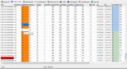
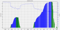
The second part of 1616259392256.log meets the description above. First and second part were flown in Pilot mode without GPS support (Mode 10). This explains why it drifted with the wind. GPS itself was OK and got GPS fix.
Mode10.pngAltitude.png
Next flight (1616259788212.log) was in Pilot-Mode with GPS.

br HE
 
  • Like
Reactions: DoomMeister
Thanks for you diagnosis.. I got your program and found it intriguing.

I have yet to get my head around it fully but it is a nice piece of work!

Does this program work with other data or just Yeneec? Is this data layout a standard?
 

New Posts

Members online

Forum statistics

Threads
20,954
Messages
241,586
Members
27,284
Latest member
csandoval