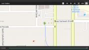
Hi all, new typhoon owner here, I had an incident happen on 4-17-21 in palm springs where my typhoon suddenly went from 2/4 battery bars to instantly 0. The feed then cut off and i could not find the drone anywhere. My guess is the battery overheated and died, but doesn't make sense why I couldnt find it at its last gps location. Flight log is attached including what the st-16 told me the last location was. Any help is greatly appreciated!