Hello Fellow Yuneec Pilot!
Join our free Yuneec community and remove this annoying banner!
Sign up

new firmware solves it - Wrong altitude on Exif Information of my H520E and E90X (with work around by h-elsner!)

Joined
Nov 12, 2020
Messages
60
Reaction score
26
Location
Bavaria / Germany
Workaround: Wrong altitude on Exif Information of my H520E and E90X (with work around by h-elsner!) #47
Here it is with file name and file extension. When in the picture folder also other stills (i.e. from DJI) are in then they can excluded from outputlist by setting filter. The status bar shows now number of jpg files - number of datasets in the output file - text messages.

This can be a workaround if the user will take the same application like you for post processing. Here is a german and a english version.

Any comment is welcome.

br HE

EDIT:
After some tests it seems that the height in EXIF stores the comma one place too far left.
Once I adjusted the decimal point position manually with the program "EXIF Pilot", the photogrammetry results were more correct.

Before correction / After correction
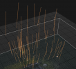
RC Original Height.png / RC Changed heigt.png
(The orange lines are the errors visually displayed, beginning of the orange line are the data from EXIF, white point is the camera position calculated by the program)


ORIGINAL:
Hi,

as already written in the title ahbe I have wrong altitude data.

This is especially serious because the height is also apparently measured incorrectly.

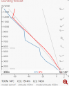
For comparison I have flown a Mavic Mini which measures a height above sea level of ~ 450 meters with a height above ground between 12 and 25 meters (I don't remember exactly)
DJI.png

But my H520E with the E90X says in a range of 25-80 meters above the ground, only a height between 49 and 55 meters above sea level see pictures.
H520E 25 meters above ground
H520E 25 Meter.png
H520E 35+ meters above ground
H520E 35+ Meter.png
H520E 50+ meters above ground
H520E 50+ Meter.png
H520E 68+ meters above ground
H520E 68+ Meter.png

What can be the reason for this?
It is very critical because I need this data for correct 3D photogrammetry scans. But I don't know why this does not fit or how I can correct it. The main problem is also that the elevation data does not fit at all.

See here, the beginning of the orange line is what the GPS EXIF data says the other end (white point/camera) is the altitude that Reality Capture calculates to make sense.... but unfortunately there are often problems when it has to be "calculated" first
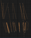
RC Kamera Alignment GPS Error.png

And these orange lines are actually "not normal" (at least they were almost never seen in such lengths on the Mavic Mini)
I hope you can help me in some way and adjusting every single image manually is not an option, because then I prefer to continue using the mini ....
 
Last edited:
I believe the altitude information in the EXIF is relative to your takeoff point, not absolute sea level.
 
was the altitude reading also off in the telemetry when flying the h520e or was it correct. what was the accuracy numbers in the aircraft gps portion of data pilot.
 
I believe the altitude information in the EXIF is relative to your takeoff point, not absolute sea level.
If this is the case, there should be no problem in Reality Caputre, because then they would be "correctly spaced"

was the altitude reading also off in the telemetry when flying the h520e or was it correct. what was the accuracy numbers in the aircraft gps portion of data pilot.
I don't know, but I'm going to do a test flight at 3 different heights and take 1 photo each + screenshot.
EDIT: Images are attached

1 meters above ground
1M.png


10 meters above ground
10M.png


60 meters above ground
60M.png


100 meters above ground
100M.png
 
Last edited:
Check the QNH for your region before the flight. Do some calculations with ICAO standard atmosphere documents.

The impossibility to add real atmospheric pressure in the software is an issue, but I'm in doubt to say, that any part of the software isn't perfect.
 
Check the QNH for your region before the flight. Do some calculations with ICAO standard atmosphere documents.

The impossibility to add real atmospheric pressure in the software is an issue, but I'm in doubt to say, that any part of the software isn't perfect.
Could be a reason, but I'm not so sure because in flightlogs the altitude is correct, but not in the pictures.

Unfortunately I can't export CVS with Q500, so it is not possible to import the flight logs into Reality Capture.1.pngThis is at my place
2.png

I don't know if this helps at all, and unfortunately I don't know anything about these things.
 
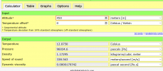
All Yuneec's (IMHO!) knows two altitudes. One of them is GPS, regardless of the geoid, and another is altimeter altitude, but relative to the starting point. If you want real altitude, related to the sea level exactly at this moment, you should know what is the atmospheric pressure in your area or know QNH for where you're starting.

Because drones flight in the near vicinity, QFE is enough for simple navigation. What is really what you can see from the telemetry. All the rest you can calculate.
I do not need the exact height above sea level, but the exact height difference between the pictures.
It doesn't matter to me if the picture was 10 meters or 1000 meters above sea level.
It plays an important role for me that picture 2 was made exactly 10 meters above picture 1.
And that it is somehow in the same scale as the GPS distances, so to speak.

So that the orange lines no longer occur.

The Logs are correct, but the Exif is not.

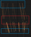
the 2 blue boxes are where the height should be, at least approximately because it was calculated.
The red box shows where the height is according to EXIF.
(This is 40 meters or even more different to 2-5 according to EXIF and yes I checked that the calculated altitude is definitely "more right")
Reality Capture.png


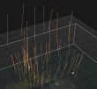
Note this is not only the altitude but 3D with GPS.
Reality Capture 3D.png
 
I faced this problem too and decide for me to use from the pictures only GPS coordinates. All the rest I'm using from the timestamp of the log. For me is important to know not only altitude but the true north and yaw of the copter from it and camera tilt and pan position. The last is a little tricky. I don't plan to share this knowledge for now, because it is tied with the channel settings, which are difficult to explain. More than, if after my explanations a crash has occurred, all the public will decide my guilty for this. ;)
 
Can you share one of the photos, so we can check the EXIF data? I assume these are the photos from the SD card on the E90X, not the ones stored on the ST-16?
 
Just want to say thank you to Helmut Elsner, who was very cooperative to change some things in his great software.
 
Can you share one of the photos, so we can check the EXIF data? I assume these are the photos from the SD card on the E90X, not the ones stored on the ST-16?
Of course and of course ;)


All Yuneec's (IMHO!) knows two altitudes. One of them is GPS, regardless of the geoid, and another is altimeter altitude, but relative to the starting point. If you want real altitude, related to the sea level exactly at this moment, you should know what is the atmospheric pressure in your area or know QNH for where you're starting.

Because drones flight in the near vicinity, QFE is enough for simple navigation. What is really what you can see from the telemetry. All the rest you can calculate.
I am just confused that I never had such problems with the Mavic Mini


Update: Logs and Pictures removed due to privacy.
 
Last edited:
Different manufacturer, different problems. Just don't say Mavic hasn't problems at all, OK? ;)

Forums are exactly for this. To point the issues and to find the solutions.
 
Last edited by a moderator:
  • Like
Reactions: Spoutnik17
I'm beginning to think that it's not a general problem but one of a few images, because when I have the "height measurement images" aligned in Reality Capture ... everything fits.
So further testing Necessary I will make an edit if I find out what the problem is.

Reality Capture.png No orange lines, as it should be
 
  • Like
Reactions: Mike Irish
So I realized that while the Mavic Mini saves 10 meters as "10.00 meters", the H520E saves 10 meters as "1.00 meters".
So to speak, the decimal point is a digit "too far" to the left in the Yuneec..
And so I think that the ratio of GPS coordinates and altitude is not correct, because it messes up reality Capture if there are different heights.

EXIF Ground DJI VS Yuneec.png
Even if the altitude readings don't match, I think you can see the difference here. Both photos on the ground in about the same position.

The question is, can I adjust or change this?
Since everything else basically fits, I can only explain that my problem is exactly related to that.

Now it is already too late over here in Germany, I will fly tomorrow with both drones, with the same weather and time, to the same altitude and compare the GPS data.
 
Last edited:
  • Like
Reactions: Mike Irish
Just checked the log files from one known flight. GPS altitude in meters over the geoid from the remote GPS well corresponds with altitude from the telemetry. Both are almost right. The taken picture in the same flight says something like 10 meters, which corresponds with no one of data.

My decision is to use LOG files for the actual shot conditions with time marks and crosschecking coordinates in the log and the EXIF. Not easy, but useful. For batch process automation is possible.

Typhoon H. ST16 and camera with the latest FW, craft with some older (my decision, not issue).
 
Can you please send the tlog file from the ST16 that matches to the photo EXIF's it would be worse to check the GPS height against the pressure related altitude.

QNH is not needed for calculation because the drone will only record differences of pressure between the one from homepoint and the actual pressure.

Gruß HE
 
  • Like
Reactions: Hypano
Just checked the log files from one known flight. GPS altitude in meters over the geoid from the remote GPS well corresponds with altitude from the telemetry. Both are almost right. The taken picture in the same flight says something like 10 meters, which corresponds with no one of data.

My decision is to use LOG files for the actual shot conditions with time marks and crosschecking coordinates in the log and the EXIF. Not easy, but useful. For batch process automation is possible.

Typhoon H. ST16 and camera with the latest FW, craft with some older (my decision, not issue).
I would like to use the Logfiles anyway but seems to be not that easy.
Can you please send the tlog file from the ST16 that matches to the photo EXIF's it would be worse to check the GPS height against the pressure related altitude.

QNH is not needed for calculation because the drone will only record differences of pressure between the one from homepoint and the actual pressure.

Gruß HE
Tomorrow (in ~14 hours) I will fly with both drones in different altitudes and at least with the Yuneec to change the position and upload the logfiles belonging to the flight.

I know that the logfiles have the right altitude, but I need them in CSV format and I'm desperate about that.
Q500logkml does not help me much in this case.

The ST16E gives me UTM, SKY, Tlog and Dronelogbook UTM.
There I can only upload UTM, everything else is not suported.

The H520E gives me ULOG (or something like that) and I can't really use it.

As said tomorrow more about it.
Thanks a lot, you have helped me a lot so far!
 
Last edited:
  • Like
Reactions: Mike Irish
If you load the .tlog file in Q500log2kml you can convert that file to CSV. There are not all data values in, but only those I have found intresting. But I can add more if you want. Go to Settings (Einstellungen) > Data analysis (Datenanalyse) and set Sensor data PX4 as CSV file (Sensordaten PX4 als CSV Datei) to true (right part of the screen).
The output format is described in Manual / Appendix as self-defined CSV format.
If you feel that there are too much information you can exclude not needed MAV link messages. The relationship of data values to MAV link messages is also described in this table with self-defined CSV format

Gruß HE
 
UAV Toolbox should allow you to replay the flight and check the altitude at the point of each photo so you can compare the reported altitude against the log altitude. If you're only experiencing this for some images, it may be that you had a poor GPS fix, but you'll need to go through a number of image sets to see if there's any consistency in the error.

I've not found an easy tool for correcting/injecting EXIF information I'm afraid, but given the H520 usually has consistent log data, it should be possible to provide the correct altitudes for each image.
 
  • Like
Reactions: Hypano

New Posts

Members online

Forum statistics

Threads
20,955
Messages
241,587
Members
27,284
Latest member
csandoval