Hello Fellow Yuneec Pilot!
Join our free Yuneec community and remove this annoying banner!
Sign up

Problems with H520 OTA-updates of Mid-January 2021? (Fix ahead)

Joined
Sep 1, 2016
Messages
187
Reaction score
83
Age
55
For everyone who is experiencing problems with compass/gyroscope calibrations and GPS stability since installing the Mid-January OTA-Updates for the H520 (and ST16s, cameras, gimbals), here is a google translation of one of my posts in a german forum:

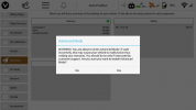
BREAKING NEWS from Yuneec Europe HQ/CS in Germany.

Here is my RMA request in full:

Hello Yuneec team,

I had just sent this email to Mr ***:
"Of course I have already carried out all the calibrations several times. Many users have these problems:
rc-drohnen-forum.de/thread/110…e/?postID=83502#post83502
After calibrating all sensors everything works initially as it should.
The compass drift problem occurs only after turning the H520 off and then on again."

The issue is problematic because many users fly once after the calibration and think that everything is OK. With some (?) copters, however, the compass drift occurs after the restart and so the H520 begins to drift immediately after taking off in GPS (Angle) mode and can only be controlled after switching to manual mode.


In response to my RMA request, I have just received the following email from Yuneec CS:

Hi there!
There will be a software update soon. Then the problem should be fixed.
Many Thanks,
With best regards,
Your Yuneec Service Team


So Yuneec Europe HQ/CS will come out with a new OTA update/fix pretty soon, I hope...

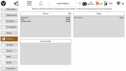
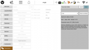
Here are two screenshots of my ST16S from yesterday:
1) correct compass indication after sensor calibrations
Screenshot_2021-01-20-17-04-16-edit.jpg

and 2) incorrect compass indication after turning the H520 off and on again
Screenshot_2021-01-20-17-06-08-edit.jpg
 
Last edited:
they add a few features to the 1st gen h520 that was on the h520e. automatic landing gear is found in vehicle area to disable auto retract when take off that need changed. max orbit that can be set is now around 3200 ft diameter about the same as h520e. payload release and bumper cage setting have been added to 1st gen h520 now. data pilot is about the same between st16s and st16e only main separation is rtk setup in st16e vs that is not in st16s
 
Last edited by a moderator:
Latest as of 2021-01-28:
There are new versions:
UpdatePilot 1.6.12 (new)
Remote Control TX 0.39.0 System 1.0.11
DataPilot 1.6.97.0 (new)

Camera E90 1.0.80 E
Flight Control 1.7.119 (new)
Gimbal 2.66.1

"H520 (Not For H520E)"

Will not come to test until tomorrow ...
Has any of you tried this before?


Latest as of 2021-01-30:
Hi Guys,
so, on Friday 29th the weather (when it was time to start) was too bad. Snow storm within the control zone of Hamburg is a bit too much "of a good thing".

Today on Saturday 30th everything was fine in terms of weather. + 2 ° C and little to no wind. All calibrations with the new OTA update (from Thursday?) ran without problems. After over 3 years there is now for the first time a UI-confirmation after the gimbal calibration of the H520 whether "it has somehow ended and worked" with the message: "Gimbal Calibration Done"

However, I noticed three things:
1) The range of the E90 (with E-Firmware) seemed worse to me today, because despite good weather without leaves on the trees, I had two telemetry interruptions, where there are usually only problems in summer with full foliage. But maybe the ice crystals floating in the air at approx. 75% humidity and "frost" are really "radio wave breakers" ...

2) Much more disturbing is the now incorrectly saved flight altitude in the EXIF data of the photos, which is an absolute NO-GO, especially when using the E90 for survey / photogrammetry:
The E90 now shows an AMSL height of 75 m instead of about 30 m at my test launch site (the difference is "coincidentally" exactly 45 m, which corresponds to my standard mission altitude. Possibly a connection?)
At 45 m altitude above the starting point (AGL-Baro), the GPS-EXIF value should correctly display 75 m AMSL, but is now 120 m (45 m AGL-Baro (ok) + 75 m AMSL (wrong))

3) The E10T shows a full 775 m in the EXIF data of the photos (RGB and T) instead of the usual 30 m AMSL height at the same test launch site. At 45 m altitude above the starting point (AGL-Baro) the GPS-EXIF values now show a "full" 1225 m instead of 75 m AMSL? displayed. That's 1150 m too much!


To 2) and 3): The telemetry data (ST16S) correctly shows 75 m AMSL for both the flights with E90 and E10T.


Could you check it out on occasion? The GPS EXIF values of both cameras were always absolutely correct from the beginning, now there are the "moon values" for the E10T and the values that seem to be exactly 45 m too high for the E90. I use the latter for survey / photogrammetry, which is currently not possible with this and therefore means "grounding" again. (Second week in a row)

I will otherwise announce this "next good news" to Yuneec CS in KK on Monday 1st Feb ...
 
  • Like
Reactions: Mike Irish
Latest as of 2021-01-28:
There are new versions:
UpdatePilot 1.6.12 (new)
Remote Control TX 0.39.0 System 1.0.11
DataPilot 1.6.97.0 (new)

Camera E90 1.0.80 E
Flight Control 1.7.119 (new)
Gimbal 2.66.1

"H520 (Not For H520E)"

Will not come to test until tomorrow ...
Has any of you tried this before?


Latest as of 2021-01-30:
Hi Guys,
so, on Friday 29th the weather (when it was time to start) was too bad. Snow storm within the control zone of Hamburg is a bit too much "of a good thing".

Today on Saturday 30th everything was fine in terms of weather. + 2 ° C and little to no wind. All calibrations with the new OTA update (from Thursday?) ran without problems. After over 3 years there is now for the first time a UI-confirmation after the gimbal calibration of the H520 whether "it has somehow ended and worked" with the message: "Gimbal Calibration Done"

However, I noticed three things:
1) The range of the E90 (with E-Firmware) seemed worse to me today, because despite good weather without leaves on the trees, I had two telemetry interruptions, where there are usually only problems in summer with full foliage. But maybe the ice crystals floating in the air at approx. 75% humidity and "frost" are really "radio wave breakers" ...

2) Much more disturbing is the now incorrectly saved flight altitude in the EXIF data of the photos, which is an absolute NO-GO, especially when using the E90 for survey / photogrammetry:
The E90 now shows an AMSL height of 75 m instead of about 30 m at my test launch site (the difference is "coincidentally" exactly 45 m, which corresponds to my standard mission altitude. Possibly a connection?)
At 45 m altitude above the starting point (AGL-Baro), the GPS-EXIF value should correctly display 75 m AMSL, but is now 120 m (45 m AGL-Baro (ok) + 75 m AMSL (wrong))

3) The E10T shows a full 775 m in the EXIF data of the photos (RGB and T) instead of the usual 30 m AMSL height at the same test launch site. At 45 m altitude above the starting point (AGL-Baro) the GPS-EXIF values now show a "full" 1225 m instead of 75 m AMSL? displayed. That's 1150 m too much!


To 2) and 3): The telemetry data (ST16S) correctly shows 75 m AMSL for both the flights with E90 and E10T.


Could you check it out on occasion? The GPS EXIF values of both cameras were always absolutely correct from the beginning, now there are the "moon values" for the E10T and the values that seem to be exactly 45 m too high for the E90. I use the latter for survey / photogrammetry, which is currently not possible with this and therefore means "grounding" again. (Second week in a row)

I will otherwise announce this "next good news" to Yuneec CS in KK on Monday 1st Feb ...
"2) Much more disturbing is the now incorrectly saved flight altitude in the EXIF data of the photos, which is an absolute NO-GO, especially when using the E90 for survey / photogrammetry:
The E90 now shows an AMSL height of 75 m instead of about 30 m at my test launch site (the difference is "coincidentally" exactly 45 m, which corresponds to my standard mission altitude. Possibly a connection?)
At 45 m altitude above the starting point (AGL-Baro), the GPS-EXIF value should correctly display 75 m AMSL, but is now 120 m (45 m AGL-Baro (ok) + 75 m AMSL (wrong))"


You are absolutely right. I have the same problem after last update.
 
Last edited:
  • Like
Reactions: vr-pilot
Tested it today. Worked like a charm!
Did you check the EXIF-Data's GPS altitude in the JPG-Files? The AMSL values seem to be wrong for E90 and E10T now...

You are absolutely right. I have the same problem after last update.
O.K. thank you. That seems to be a general Problem for all users...

Mistake in EXIF metadata (wrong altitude). Real altitude over sea level 138 meters. In EXIF i see 182 meters. Camera E90. I made test 30 min ago.
Wow, that sounds also like adding about 45 m to the EXIF-GPS values like my E90 now does.
(My E10T added up to 1150 m (!) in my last flight)
 
I just sent this mail to Yuneec after the last smaller update:

I would need two more clarifications:
  • Could you explain me what function do have the buttons T3 and T4 from the annex have? One of them is the zoom, yet T4 doesn't seem to do anything anymore. Formerly T3 was the big zoom steps, and T4 the small zoom steps.
  • when activation the geofence with the HOLD function, the drone gets stuck. Only way of getting him back is doing a RTL, yet I don't want that. Sometimes doing that is dangerous, and moreover, during a mission, I don't want to restart all over again. Can I change the HOLD setting to WARNING once it gets stuck (so during the flight)? Why can't the hold not just stop the drone at the boundary, but let me continue to fly? Is switching in the settings to WARNING going to work? That would be a work around, yet best would be if the HOLD function is just to hold the drone within the boundaries, not to force a RTL...
Besides these clarifications, I really do have an urgent request that should be very easy to implement as before it was implemented. Can you please return the function ROI? I really would need this function, which I used many times before. All of a sudden, this function is gone without notice, yet this was a major advantage of the H520 compared to other drones...

Is it possible that the connection range with the E90 is worse than before since the last updates? Yesterday I went for a fly, clear sky, no obstructions, yet I twice had an interruption of the camera during flight...

Also, I noticed that the height in the EXIF data of the E90 is wrong I get height indications of 170 to 210m, yet I never was above 120m (my geofence is set to 120m). It's not the difference between AMSL and AGV, as the GLV is at 49m. When flying at 120m I get an indication of 210m, so 90m (!) difference.


For me these are the main findings after two batteries yesterday in the open field...
Too bad Yuneec doesn't provide a log of the changes...
 
  • Like
Reactions: vr-pilot
they add a few features to the 1st gen h520 that was on the h520e. automatic landing gear is found in vehicle area to disable auto retract when take off that need changed. max orbit that can be set is now around 3200 ft diameter about the same as h520e. payload release and bumper cage setting have been added to 1st gen h520 now. data pilot is about the same between st16s and st16e only main separation is rtk setup in st16e vs that is not in st16s

WHere did you find the setting for the max orbit? If I'm right that's the same as the former ROI? Yet it seems to be gone. Thanks for your clarification (if possible with images so I can find it on mine).
 
Did you check the EXIF-Data's GPS altitude in the JPG-Files? The AMSL values seem to be wrong for E90 and E10T now...


O.K. thank you. That seems to be a general Problem for all users...


Wow, that sounds also like adding about 45 m to the EXIF-GPS values like my E90 now does.
(My E10T added up to 1150 m (!) in my last flight)
u r right about the EXIF!
 
the orbit settings is found in the advance hidden setting in the parameters in the datapilot listed only when connected to the h520.. the geofence set to hold will freeze the unit in place where it goes bit beyond what you set it at.. the unit will still breach it and then locks down at that height you will not be able to get the h520 back below the setting where the h520 holds. only way is rtl. you can not change geofence setting in flight from hold to warning. now if the can get the geofence to work like what was on h480 that unit held right at and not pass the agl you set and remained completely under your control no freezing at that spot because it will not go above the prescribed limit you set at all.
 
well it not just yuneec having issues with gps exif. other manufactures are having about the same issues with it as well. I wonder if yuneec is identifying absolute barometric altitude as the gps altitude for exif and not the actual gps reading at the time of the flights. which is what dji has been doing and there users are having about the same issues with the exif data.
 
There are a few thing I want to try on the st16s datapilot software thirdparty mapset area. but that have to wait till I can get the weather to fly which will be march 1st to 5th at the soonest.
 
the orbit settings is found in the advance hidden setting in the parameters in the datapilot listed only when connected to the h520.. the geofence set to hold will freeze the unit in place where it goes bit beyond what you set it at.. the unit will still breach it and then locks down at that height you will not be able to get the h520 back below the setting where the h520 holds. only way is rtl. you can not change geofence setting in flight from hold to warning. now if the can get the geofence to work like what was on h480 that unit held right at and not pass the agl you set and remained completely under your control no freezing at that spot because it will not go above the prescribed limit you set at all.
Where do you mean: in the same location as the waypoints, corridor scan, structure scan etc? Am I right that the ROI is gone since the last update?
 
no it's in a completely different are in data pilot it a main menu item that is hidden. to access it you must hit main menu button in datapilot three or more times there you will get a prompt that warns you are about to go to open up the advance settings area once there if the h520 is up and running you can get to the parameters menu it's in that menu that the orbit setting are. it may be locked for the h520 however I set it to near max settings as indicated by datapilot that test will be in march to see if it took hold.
 
  • Like
Reactions: aedronix
no it's in a completely different are in data pilot it a main menu item that is hidden. to access it you must hit main menu button in datapilot three or more times there you will get a prompt that warns you are about to go to open up the advance settings area once there if the h520 is up and running you can get to the parameters menu it's in that menu that the orbit setting are. it may be locked for the h520 however I set it to near max settings as indicated by datapilot that test will be in march to see if it took hold.
And is the ROI also hidden there? Can I reactivate the ROI in that hidden menu too?
 
here more detailed use with extreme caution.
 

Attachments

  • Screenshot_2021-02-01-09-12-09.png
    Screenshot_2021-02-01-09-12-09.png
    83.4 KB · Views: 29
  • Screenshot_2021-02-01-09-12-16.png
    Screenshot_2021-02-01-09-12-16.png
    93.3 KB · Views: 30
  • Screenshot_2021-02-01-09-13-05.png
    Screenshot_2021-02-01-09-13-05.png
    104.3 KB · Views: 28
  • Screenshot_2021-02-01-09-13-15.png
    Screenshot_2021-02-01-09-13-15.png
    125.4 KB · Views: 27
  • Screenshot_2021-02-01-09-13-30.png
    Screenshot_2021-02-01-09-13-30.png
    104 KB · Views: 31
  • Like
Reactions: aedronix
now the setting may be locked down by yuneec for 1st gen h520 but second gen h520e the usable radius is by far larger. I have not tried to see where the max for that is yet but it was approaching one mile easy
 
roi testing will be done in march when I am on vacation. That looks like the soonest time the weather were I be at is flight suitable.
 
  • Like
Reactions: aedronix
roi testing will be done in march when I am on vacation. That looks like the soonest time the weather were I be at is flight suitable.
But do you still see the ROI function? It was always below the waypoint and above the structure scan, yet since the last update it seems to be missing...
 
Is it possible that the connection range with the E90 is worse than before since the last updates? Yesterday I went for a fly, clear sky, no obstructions, yet I twice had an interruption of the camera during flight...
Same here!

Also, I noticed that the height in the EXIF data of the E90 is wrong I get height indications of 170 to 210m, yet I never was above 120m (my geofence is set to 120m). It's not the difference between AMSL and AGV, as the GLV is at 49m. When flying at 120m I get an indication of 210m, so 90m (!) difference.
Also, same here.
 
  • Sad
Reactions: aedronix

New Posts

Members online

No members online now.

Forum statistics

Threads
20,955
Messages
241,588
Members
27,284
Latest member
csandoval