Hello Fellow Yuneec Pilot!
Join our free Yuneec community and remove this annoying banner!
Sign up

H520E RTK From the Box Up

they said that the most important benefit of Li-Ion would be better long term storage behaviour when being fully charged.
This was so sorely needed! I can't tell you how many H520 batteries I have gone through over the past couple of years due to swelling or voltages dropping on individual cells. Once I get 0.2-0.3v out of balance consistently it's time to go. It's interesting how the stock batteries puffed vertically and the high capacity GiFi's did it horizontally...

Did you already check the Exif-Data of the E90X jpegs? Are the GPS altitudes correct? Do they show AMSL or ellipsoid altitude?
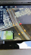
I just checked one of the flights from this morning and it was the ellipsoid. I ran NTRIP to our RTK network. I will be testing a casted base for PPK in the next couple of weeks once I have gotten comfortable with this and have some time to take a breath. Seven projects in two days has become a little cumbersome.
 
Last edited:
  • Like
Reactions: vr-pilot
Gave the bird a run at 3 projects today, one of them being 60 acres so I am anxious to see the residuals in comparison to my small home test.

A few notes from today:
  • 22m30sec to 30% battery remaining.
  • 2400ft range successful
  • Had 2 - 5sec blips of lost data most likely due to the turn being over a high electrical line
  • ST16E ran 1h30m to 20% battery remaining
  • Confirmed that multi-battery missions had the image capture from home to resume point unless a 0ft turnaround was set
  • Things that need to be worked on
    • Turnaround characteristics, this one bugs the heck out of me. Stop, yaw, straight for 2-3sec, stop, yaw and commence. This very odd thing is that it seems to be banking out of the corner which leads me to ask the question of why can't it bank (rotating strafe) throughout the entire turn. The banking into the next leg actually causes an image to be captured while rotating so keep an eye on them.
    • The system configured flight speed is way to high. With a rolling shutter you should never be flying much faster than 15mph and the initial project tried to run 22mph with a 1.5sec capture interval. Always adjust to 2-2.5sec. Is this a possible camera configuration problem with there not being a specific E90X profile? They are reportedly the same but I can guarantee they aren't with the difference in configurations I am seeing.
That said here's some eye candy. I will upload some map data once the finish.

Fancy 5gal bucket lid GCP ?
1618267888393.png1618267996350.png1618268065749.png1618268190512.png1618284403780.png1618284471802.png
 
Last edited:
I have the data back from the larger site that I flew and as I expected the photo relocation residuals went up, but they went up more than I expected which I am finding out is due to the larger perimeter of images that didn't have enough matches and the tie-point coverage was weekend. I would be really interested to see the P4RTK's results on sites larger than 50 acres in comparison. That said my checkpoints were still better than a regular P4Pro with twice as many GCP's at 20 vs 8. Check out the Z value! I just don't understand why the XY would be worse but I suppose that has something to do with the reduction in GCP's. I really hope I have time soon to walk through the PPK process. If anyone has any experience with it on the H520E RTK it would be greatly appreciated.

H520E RTK with 8 GCP's
1618406143004.png

P4P with 20 GCP's
1618406353473.png

Here is another map I flew yesterday which was an asbuilt of a site we completed about a month ago. On asbuilt we fly the standard nadir flight for civil site grading but also perform an oblique crosshatch to make a separate 3D model. This one was done without any feature obliques for each building, just the obliques from the flight at 125ft AGL. The H520E RTK did a fine job.

1618406679159.png1618406740830.png

...and the camera relocations. Not what I want to see, but again the Z is beautiful. I will note as well that the camera focal point variance from intrinsics is actually better with the oblique imagery than the nadir, which I did not expect.

1618406866474.png

1618406978959.png
 
Ok! Got the cables from YuneecSkins and modified one of them to work in my X8 iCharger. It was really nice to see the cells and be able to balance them to storage levels SINCE THE OEM CAN"T. :mad: 
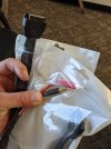
That's bull to me considering how much we pay for these things. I've got 8 batteries now and they were all over the place. I also notice that the two that came with the bird were obviously a much different batch so i'll keep my eye on them. The labels were very faded and they are obviously a little lighter orange than the drone and the other batteries I purchased separately. I've really got to find a new development contact because the deeper I dig into this thing the more I find that needs to be tweaked to make the H520E RTK a serious contender for one of the best all around drones out there. It could easily be a better mapper than the P4RTK. Thought I'd throw in a pic of my other baby while I am out here.

PXL_20210417_202208830.jpgPXL_20210417_202624444.PORTRAIT.jpg
 
have you tried to charge one of the h520e batteries with cube then use the third party cable setup to measure the voltage on each cell to see what oem charger Chargers the battery to.
 
have you tried to charge one of the h520e batteries with cube then use the third party cable setup to measure the voltage on each cell to see what oem charger Chargers the battery to.
I charged two batteries with each the OEM charger (cube?) and the X8 and the resting voltage was 0.05v (+/- 0.02v) higher on the X8 batteries. The H3 charger will be here in a couple of days and I will test again, but I already purchased another X8 and will be using them moving forward.
 
Last edited:
We now have 14 missions in with 6 of them being multi-battery and everything is operating great. NTRIP settings are persisting and go fixed very quickly. I am still digging into PPK so no verification on fixed condition stability but the checks that I have done on the maps have been within our 0.10ft tolerance. I have done a few flights without GCP's and found that in our scenario that it is not a viable option. In construction we very often have control that is just enough off of our SPCS to get outside of tolerance, most of this being due to the fact that we use project localizations which best-fit the SPCS control to the ground condition and level-looped benchmarks. More to come but if you are interested in the PPK effort follow this thread.

 
  • Like
Reactions: vr-pilot
Wow, found another flight flaw. Running the first corridor mission on this new unit and the bird is doing a 360° turn at each waypoint, lol. Where are the developers?!
 
  • Like
Reactions: vr-pilot
Do they even QA/QC?
After my H520's January 2021 updates I also noticed some strange waypoints behaviour using DataPilot:
As we talked about earlier, the survey turnaround legs "irritations" can be "heald" by setting turnaround distance to "0" - plus: disabling taking images in turnarounds.
Your new bug/feature "corridor waypoint re-positioning" effect may be caused by too narrowly set GPS tolerances within the DataPilot/AutoPilot (subject: real time positioning based on RTK data)? I noticed this on "normal" waypoints where my "good old H520" retried entering the correct position several times (what he never did the last 40 months). Maybe this is also related to the "horizontal position drift" warning issues?
I did not run any corridor scans since these last updates, but I have some in the planning. So I will check soon. The H520E and the H520 are for sure not the same birds, but they do share quite a substantial mass of identical "DNA"...
 
  • Like
Reactions: chascoadmin
After my H520's January 2021 updates I also noticed some strange waypoints behaviour using DataPilot:
As we talked about earlier, the survey turnaround legs "irritations" can be "heald" by setting turnaround distance to "0" - plus: disabling taking images in turnarounds.
Your new bug/feature "corridor waypoint re-positioning" effect may be caused by too narrowly set GPS tolerances within the DataPilot/AutoPilot (subject: real time positioning based on RTK data)? I noticed this on "normal" waypoints where my "good old H520" retried entering the correct position several times (what he never did the last 40 months). Maybe this is also related to the "horizontal position drift" warning issues?
I did not run any corridor scans since these last updates, but I have some in the planning. So I will check soon. The H520E and the H520 are for sure not the same birds, but they do share quite a substantial mass of identical "DNA"...
Yep and that DNA is DP. I am actually seeing some of the quirks in flight that we went through in beta when building the flight plans almost 6 years ago. It's almost like some of the DP 1.4 code came back.
 
Last edited:
  • Like
Reactions: vr-pilot
After going through the images last night before getting ready to start processing I noticed that the last image was at horizon. ? So I tracked back and it appears that about halfway through the last leg and apparently right after a waypoint at which the drone did the "Yuneec Spin" ? that the camera pitch went from nadir to 0. I am pretty sure there is nothing I did to cause this as the pitch lever stays up during a mission and I at no point interrupted the mission. I will try the same flight again to see what happens but this would be a devastating bug if that's what it turns out to be. Good thing this project is only miles from our office...
 
  • Like
Reactions: vr-pilot
So I tracked back and it appears that about halfway through the last leg and apparently right after a waypoint at which the drone did the "Yuneec Spin" ? that the camera pitch went from nadir to 0.
Wow, that's AI ;)
Setting the gimbal from nadir to 0 would be normal e.g. prior to the landing phase (which is good in order to keep the camera lenses out of dirt, dust, little stones or wet grass on T/D).
But saying "well, we're done" before the last leg was completed is a true machine error with "a human touch" ?

A bit offtopic here another DP issue I have to check again after the January 2021 OTA update series in the coming days:
As my standard for the E90 I use the "Cloudy" W/B setting (for being close to 6500 K regarding the D65 neutral white recommendations) in conjunction with "A/E average", "EV+/-0", "unprocessed", "no distortion correction" and "ultra jpeg" settings for my imagery.
Some months ago I tried to use manual exposure times in order to adopt to different ground speeds... But when I interrupted the survey mission by stickinputs, the ST16S screen's camera view got fully white. I soon noticed that it was due to the DP setting the manual exposure time to a max of 4 seconds... I tried the same procedure several times and the "white screen of blind flight" always came up. So it is not really "recommendable" to use manual exposure... Have you tried or noticed that already?
 
But saying "well, we're done" before the last leg was completed is a true machine error with "a human touch"
LOL, first it decides it wants to dance and then decides it was tired of taking pictures of the ground. Sassy little copter! Good news is that I think I hit the right button and am going to get some time with Yuneec R&D. Time to get this deal ironed out.

I tried the same procedure several times and the "white screen of blind flight" always came up. So it is not really "recommendable" to use manual exposure... Have you tried or noticed that already?
Never used manual exposure myself so no but I could give it a try. The original H520? PM me your FW versions.
 
  • Like
Reactions: vr-pilot
Some quick battery/charger results...

After a 4 hour resting state all chargers resulted in 4.36v per cell +0.005v/-0.015v. In our scenario the H3 DY5 will work just fine.

Storage
  • OEM - No Storage
  • X8 - x.xxv, 2h10m @ 3a
  • H3 - x.xxv, 3h17m @ unknown

Charge from Storage
  • OEM - 4.37v @ unknown
  • X8 - 4.38v @ 4a
  • H3 - 4.34v @ unknown
 
First map processed and I am pretty happy with what I see at first glance. The first nice surprise was to see that DroneDeploy recognized not only the E90, but that it was an E90X. The main values I wanted to see were the camera optimization variance and the RMSE of the Camera GPS Locations. These are both values that give the algorithm the most trouble in eliminating warping.

While a 0.03% variation from reference intrinsics in camera optimization is excellent I am more concerned with the separation of the principal point (spec'd center) to the CCD (calculated) center. This tells me that the E90X camera does not have a very good calibration or a profile that compensates well for the lack of calibration. Although we do have to remember that this is rolling versus global shutter and that the P4RTK is supposedly uniquely calibrated.


View attachment 25360

...and here's a Phantom 4 RTK

View attachment 25359


The more important value though is the RMSE of the camera GPS locations. These are without GCP's. Non-RTK is usually around 1m depending upon the conditions and quality of the satellites that day. Most RTK reports that I have seen have been right around a 10cm range. On this test the H520E RTK was better than the P4 RTK.

View attachment 25361

P4RTK Samples
View attachment 25362
View attachment 25363

Overall I am really happy with what I see and hope that it continues or even gets better as I get it tweaked. Another task I will take on is figuring out the PPK side. I see files getting populated all over the place but have no idea what to do with them yet. Has anyone seen ANY information on the PPK process?
excuse me but how do you rate RMSE of the images? While on the Ph4 in real time you know the rtk error here you can't or is there a way??
 
First map processed and I am pretty happy with what I see at first glance. The first nice surprise was to see that DroneDeploy recognized not only the E90, but that it was an E90X. The main values I wanted to see were the camera optimization variance and the RMSE of the Camera GPS Locations. These are both values that give the algorithm the most trouble in eliminating warping.

While a 0.03% variation from reference intrinsics in camera optimization is excellent I am more concerned with the separation of the principal point (spec'd center) to the CCD (calculated) center. This tells me that the E90X camera does not have a very good calibration or a profile that compensates well for the lack of calibration. Although we do have to remember that this is rolling versus global shutter and that the P4RTK is supposedly uniquely calibrated.


View attachment 25360

...and here's a Phantom 4 RTK

View attachment 25359


The more important value though is the RMSE of the camera GPS locations. These are without GCP's. Non-RTK is usually around 1m depending upon the conditions and quality of the satellites that day. Most RTK reports that I have seen have been right around a 10cm range. On this test the H520E RTK was better than the P4 RTK.

View attachment 25361

P4RTK Samples
View attachment 25362
View attachment 25363

Overall I am really happy with what I see and hope that it continues or even gets better as I get it tweaked. Another task I will take on is figuring out the PPK side. I see files getting populated all over the place but have no idea what to do with them yet. Has anyone seen ANY information on the PPK process?

on the ppk process there's a huge lack on the part of yuneec assistance
 
  • Like
Reactions: chascoadmin
on the ppk process there's a huge lack on the part of yuneec assistance
Be assured that we'll get it figured out. The same thing happened with the P4RTK and it took us 3 months to get a proper workflow figured out. I can promise you that I won't let up until they show the effort. Supposedly they already have a group in Oklahoma that is doing it successfully. That's all I can share for now but I will update later.
 
  • Like
Reactions: ermaITA
Good morning from Texas! Is Datapilot Planner 1.5.0.1 the latest version? I couldn't find any links that work online or in other threads. Or should I just stick with 1.4.44.40?
 
  • Like
Reactions: vr-pilot

New Posts

Members online

Forum statistics

Threads
20,952
Messages
241,578
Members
27,284
Latest member
csandoval