Hello Fellow Yuneec Pilot!
Join our free Yuneec community and remove this annoying banner!
Sign up

H520E RTK using PPK

Joined
Nov 28, 2019
Messages
524
Reaction score
308
Age
49
Location
Austin, Texas
I am starting this thread to talk specifically about performing PPK with the H520E RTK data. Please confine your thoughts to that and hopefully we will end up with a concise guide.

I am currently running with RTK corrections and have about 9 flights in but I am not liking the residuals that I am seeing on camera GPS value relocations as the projects get larger. The checkpoints have been within our 5cm (+/- 0.15ft) tolerance, but as the project gets larger the residuals on the camera locations start approaching 1.5ft XY. The awesome part is that the verticals are staying right around 5-6cm or below.

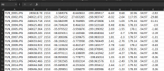
My primary reason for wanting to do PPK is to have verification of the RTK flight. Those who have flown a P4RTK and have not checked their data via PPK are not providing work to actual survey-grade and would not be accepted by a PLS. I have seen the PPK Timestamps file that is be created in the images folder, but do not quite see how that is going to help anything regarding PPK... and what are the values in the columns?!

Please note your experience as you go there! It's really a shame that it is marketed as capable but there is absolutely no direction from Yuneec development.

1618412997100.png

If you are interested in other testing and updates on the use of the H520E RTK in construction mapping check out this thread.
 
I am starting this thread to talk specifically about performing PPK with the H520E RTK data. Please confine your thoughts to that and hopefully we will end up with a concise guide.

I am currently running with RTK corrections and have about 9 flights in but I am not liking the residuals that I am seeing on camera GPS value relocations as the projects get larger. The checkpoints have been within our 5cm (+/- 0.15ft) tolerance, but as the project gets larger the residuals on the camera locations start approaching 1.5ft XY. The awesome part is that the verticals are staying right around 5-6cm or below.

My primary reason for wanting to do PPK is to have verification of the RTK flight. Those who have flown a P4RTK and have not checked their data via PPK are not providing work to actual survey-grade and would not be accepted by a PLS. I have seen the PPK Timestamps file that is be created in the images folder, but do not quite see how that is going to help anything regarding PPK... and what are the values in the columns?!

Please note your experience as you go there! It's really a shame that it is marketed as capable but there is absolutely no direction from Yuneec development.


View attachment 25410

If you are interested in other testing and updates on the use of the H520E RTK in construction mapping check out this thread.
I have no experience in RTK & PPK but would follow this thread very close to gain one.
 
My primary reason for wanting to do PPK is to have verification of the RTK flight
Hi chascoadmin,
I really appreciate your reports on the H520E-RTK usage.
I am really looking forward to learn more about PPK capabilites in the Yuneec universe. E.g. like the Wingtra Hub, which is also a PX4-based system. Wingtra btw. recommends PPK in order to have less CORS repositioning errors within the Exif Data, less connection issues (network or base/rover-link interruptions or absence) during narrow time frame missions and because of the highest overall accuracy without the obligatory use of GCPs.
Although I just bought 12 new GCPs, I am actually looking forward to not using them anymore in the near future.
 
Can you translate abbreviations to the public? CORS, GCP?

IMHO, to use PPK the owner should have their strategy. To use someone's is not so good and will not give satisfactory results.
 
Can you translate abbreviations to the public? CORS, GCP?

IMHO, to use PPK the owner should have their strategy. To use someone's is not so good and will not give satisfactory results.
CORS - Continuously Operating Reference Station. It's basically a GNSS receiver used as a base to send corrections that is always on and accessible via the internet.

GCP - Ground Control point. This is a point on the ground that is visible from the air that is surveyed to provide a centimeter-level accurate point used for geometric corrections in photogrammetry.

PPK - Post Process Kinematics. I'm not quite sure what your statement means but PPK is a method of corrections that is the same for everyone. We all use the same satellite constellations and there's only so many ways that you can really manipulate the data so the only difference is would be our actual gnss hardware and software that collects the data but the end form of the data is always the same.
 
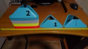
Can you post here a photo of one of your GCP's? How big is this one?
How do you fix it to the ground?

Later today I'll post a picture of myne piramids. Now called GCP's yet.
 
Last edited:
I would not recommend these for GCP's. An anomaly in triangulation will occur because of the raised surface and multiple angles that will create incorrect tie-points. Because of this you will never be able to maintain the cm-level accurate reading from a survey receiver which is pretty much the entire point of having GCP's. We use orange 5-gallon bucket lids with the center blacked out. They are $1.50ea at the store but we get them in bulk for $1.10ea from a supplier. This is a 2000% magnification.

1618747338924.png
 
I would not recommend these for GCP's.
They're not ready for use yet. On the top of them I'll put some orrange painted tennis balls with sand inside. The piramids itself are with very low weight and copter moves them from a few meters AGL.

I'm not ready with complete solution too.
 
They're not ready for use yet. On the top of them I'll put some orrange painted tennis balls with sand inside. The piramids itself are with very low weight and copter moves them from a few meters AGL.

I'm not ready with complete solution too.
A tennis ball is too small to consistently reconstruct unless you are always flying lower than 200ft AGL 0.5in/px with a P4P. This only provides 4-5px cubed. You are making the elevation difference between the ground and the point even worse. Where do you plan on acquiring the survey point? Surely not on top of the ball... GCP's should be as flat as possible and on a flat space at least a meter across.
 
The task will start with a few predetermined points. First of them will be precised by the GPS with raw data output. The AGL will be 30 meters/100 ft or so. This will be an error correction aquisition. After the survey I'll do the same. All the rest is approximation between the points.
 
Ok, sounds like you have a process that works for you. This is not even close to the majority of mapping scenarios. Regardless none of that has anything to do with PPK on the drone. Please stay on topic.
 
Last edited:
So this week we'll start deciphering what it means to PPK with the Yuneec H520E RTK... The only clues I have seen so far without really digging into it are:
  1. The marketing statement that it is PPK ready and raw GNSS can be logged "onboard".
  2. PPKTimestamp.txt file populated inside DCIM included with each photo session detailing the second of capture, orientation characteristics and heading but no coordinate values. The file is inclusive of all images that were taken that day so it would probably be advantageous to run an mSD per project...
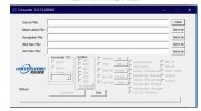
  3. The Converter3.0.7 EXE on root of mSD. Gets loaded with every format.
  4. PPKRAW.UNC on root of mSD. Apparently the raw GNSS logs of the drone. How does it break sessions? Another reason to run an mSD per project?
  5. ppk_convert.bat, appears to be a rename and cleanup routine to acquire the OBS file for PPK against a base source.
My initial test will be to set a base point via RTK with the Emlid Reach RS2, manually enter that coordinate into Base Mode and then log for the duration of the flight. There should be no connection between the base and the drone needed. I will need to see what settings determine which GNSS files get saved. Hopefully the only difference in PPK workflow is getting the drone OBS created successfully in the correct RINEX format to be used in RTKLIB with the RS2 base log.
 
O yüzden bu hafta Yuneec H520E RTK ile PPK'nın ne anlama geldiğini anlamak ... Şimdiye kadar gerçekten derinlemesine inceleden öğrenmek tek ipuçları:
  1. PPK'ya hazır ve ham GNSS mezun dair pazarlama beyanı "onboard" olarak kaydedilebilir.
  2. DCIM içinde doldurulan PPKTimestamp.txt dosyası, onun bir fotoğraf oturumunda, ikinci yakalama, oryantasyon özellikleri ve istikameti ayrıntılarıyla, ancak koordinat dahil olmadan dahil edilmiştir. Dosya, o gün gönderilen tüm şifreleri içerir, bu devam eden proje başına bir mSD araştırmanın avantajlı olacaktır ...
  3. MSD'nin kökündeki Converter3.0.7 EXE. Onun formatta yüklenir.
  4. MSD'nin kökünde PPKRAW.UNC. Göre dronun ham GNS Görünüşe günlükleri. Seansları nasıl kırar? Proje başına mSD çalıştırmanın başka bir nedeni nedir?
  5. ppk_convert.bat, PPK için OBS temiz temel bir kaynağa karşı almak için bir yeniden adlandırma ve temizleme rutini gibi görünmektedir.
İlk test, Emlid Reach RS2 ile RTK için bir temel nokta belirlemek, bu koordinatı Baz Moduna manuel olarak girmek ve ardından uçuş süresi için günlüğe kaydedilecek. Üs ile gerekli drone arasında zenginleşmelidir. Hangi ayarların hangi GNSS dosyalarının kaydedileceğini belirlediğini görmem gerekecek. Umarız PPK iş akışındaki tek fark, drone OBS'nin RS2 temel günlüğü ile RTKLIB'de kullanılmak üzere doğru RINEX ince değişik yaratılmasıdır.
Merhabalar;
Bu verileri RTKLIB Kullanmak üzere hazırlıyorum.
Fakat sabitleme ile exif seansını eşleştirmiyor.
 

Attachments

  • 1.JPG
    1.JPG
    101.3 KB · Views: 19
  • 2.JPG
    2.JPG
    151.9 KB · Views: 20
Merhabalar;
Bu verileri RTKLIB Kullanmak üzere hazırlıyorum.
Fakat sabitleme ile exif seansını eşleştirmiyor.
Could you please translate? I tried and "sabitleme" came up as "fixation" which confuses the context. Are you talking about the fixed RTK solution not tagging the photos? Are you referencing use of the H520E specifically?
 
Could you please translate? I tried and "sabitleme" came up as "fixation" which confuses the context. Are you talking about the fixed RTK solution not tagging the photos? Are you referencing use of the H520E specifically?
Hello;
First, I apologize for the translation.
I can't get any results when I process the base station's Rinex data with the H520E-RTK Rinex data using the RTKLIB program.
I contacted Yuneec Europe, but I couldn't find a contact.
 
I contacted Yuneec Europe, but I couldn't find a contact.
I really hope we can grow a good following for this drone and have some sort of influence on their customer support effort for it. Or I will just do it myself... :rolleyes:

What base are you using? What version of Rinex is it putting out?
 
I received the rubber spacers and it worked out just as I had hoped. The only difference is that I ordered 1/16in because I could not find 1/8th in the right size. This should seal that area nicely, reduce vibration and add a little tension to the mounting of the antenna so that you don't have to worry about it backing off.


PXL_20210419_150431612.jpgPXL_20210419_150437164.jpg
 
Last edited:
  • Like
Reactions: vr-pilot

New Posts

Members online

Forum statistics

Threads
20,955
Messages
241,587
Members
27,284
Latest member
csandoval