

You are using an out of date browser. It may not display this or other websites correctly.
You should upgrade or use an alternative browser.
You should upgrade or use an alternative browser.
Hplan - Typhoon H CCC route planning web app
- Thread starter dotsi
- Start date
-
- Tags
- automation ccc typhoon h waypoints
First of all, great app... I hope you haven't stop developing it as it's been a while since anybody has commented on it here...!!
I have one question, when I use my MacBook with the app, it doesn't show me the elevation (have tried both Safari and Crome). Any suggestions...??
I have one question, when I use my MacBook with the app, it doesn't show me the elevation (have tried both Safari and Crome). Any suggestions...??
First of all, great app... I hope you haven't stop developing it as it's been a while since anybody has commented on it here...!!
I have one question, when I use my MacBook with the app, it doesn't show me the elevation (have tried both Safari and Crome). Any suggestions...??
I'm glad you like it!
") We didn't stop the development, we have many more features and ideas coming in the future. Stay tuned.
We didn't stop the development, we have many more features and ideas coming in the future. Stay tuned.Uh, that's strange.. On my macbook everything works alright. Do you mean it doesn't show the elevation Graph or it doesn't even display the elevation value in the sidebar when you place a Home point?

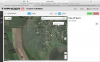
My problem is first and foremost the elevation value in the sidebar, the app doesn't display either the homepoint elevation or waypoint elevation. I have attach a screenshot from Safari, but it's the same running Chrome.. I'm using a fairly new Macbook 12", so if you have it working on your Macbook, it must be something in my settings, I just don't know what...!!
It great to hear you're still developing new features, looking forward to see them...
It great to hear you're still developing new features, looking forward to see them...
Attachments
Okay then, can you click on this link and tell me what does it say?
https://maps.googleapis.com/maps/ap...4&key=AIzaSyA8pqFhwNwGCAXmXxzlnGhc-CLB7OBN9Ik
Do you see the elevation value? What does "status" say?
https://maps.googleapis.com/maps/ap...4&key=AIzaSyA8pqFhwNwGCAXmXxzlnGhc-CLB7OBN9Ik
Do you see the elevation value? What does "status" say?
Okay then, can you click on this link and tell me what does it say?
https://maps.googleapis.com/maps/ap...4&key=AIzaSyA8pqFhwNwGCAXmXxzlnGhc-CLB7OBN9Ik
Do you see the elevation value? What does "status" say?
As far as I can tell, that works fine(see screenshot)..
Attachments

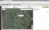
Yes, I see. So that means there is no problem with you getting google elevation data, it has to be something else.As far as I can tell, that works fine(see screenshot)..
Ok, I have a couple of ideas for you to try. First did you try to place the Home point or waypoints somewhere far from you, like another part of the world for example. If that gives you elevation data, one possibility would be that there is no Google elevation data to display for your part of the world, although I find that highly unlikely.Here's a screenshot from Chrome, no elevation value there either...
You could export your flight and attach the file here so I can try to replicate your problem, but I'm away for the weekend and won't be able to look at it till Monday.
And if you happen to know how to check for errors in the Chrome Developer Tools
, that would also be of help, because I really wonder what kind of error(s) (if any) you get.- Joined
- Aug 23, 2016
- Messages
- 104
- Reaction score
- 21
Hi guys,
My friend and I have been hard at work at a Waypoint planner web app for the Typhoon H. I just found out that in the meantime another app like this popped up. Oh well, you can decide which one you like best.
Flight Planner H - Waypoints Creator for Yuneec Typhoon H
The app is working well but we are still adding and optimising every day. Please take some time to test it and provide some feedback and suggestions. Also please ask any questions here.
Hey dotsi ...
Very nice app ... I created a ccc route .. saved it .. reloaded it ... modified it .. saved it again ... all very easy and quickly. Not sure if it would be possible at all but once you have a ccc route made it would be nice to try it ... in other words animate it so you could actually see it in maybe 3D with your app. I have yet to load my route on the ST16 and I know I would be able to view it in motion there but not be able to view in 3D only 2D. Any chances or am I only dreaming ??
- Joined
- Aug 23, 2016
- Messages
- 104
- Reaction score
- 21
Hey dotsi ..
I just downloaded Chrome browser on my ST16 and it installed fine ... bookmarked your app to my home page on the ST16 and then installed the CCC route I created on my desktop via sd card into the flight mode folder and was able to view it on your app ... however ... none of the flight data (alt, yaw, gimbal/pitch) showed up on the side bar on the ST16. The data does show up when I view the route with Chrome on my desk top. Not sure if there is a bug or if I am doing something wrong .... ???
I just downloaded Chrome browser on my ST16 and it installed fine ... bookmarked your app to my home page on the ST16 and then installed the CCC route I created on my desktop via sd card into the flight mode folder and was able to view it on your app ... however ... none of the flight data (alt, yaw, gimbal/pitch) showed up on the side bar on the ST16. The data does show up when I view the route with Chrome on my desk top. Not sure if there is a bug or if I am doing something wrong .... ???
Yes, I see. So that means there is no problem with you getting google elevation data, it has to be something else.
Ok, I have a couple of ideas for you to try. First did you try to place the Home point or waypoints somewhere far from you, like another part of the world for example. If that gives you elevation data, one possibility would be that there is no Google elevation data to display for your part of the world, although I find that highly unlikely.
You could export your flight and attach the file here so I can try to replicate your problem, but I'm away for the weekend and won't be able to look at it till Monday.
And if you happen to know how to check for errors in the Chrome Developer Tools
I tried installing Firefox and there elevation and anything else works fine.
If I make a waypoint flight plan in Chrome or Safari all waypoint show me 0 Altitude, 0 Yaw, 0 Gimbalpitch and no elevation data as you can see on attach picture. If I save and download the flight plan is seem like
all elevation, altitude, yaw and gimbal pitch setting are being registred...
It seems strange to me, but it might be Norton Security is blocking the showning of the data in Safari and Chrome..!
Can you figure it out...?
Anyway thanks for your time and help.
Attachments


Hey guys,
great news! We've been working hard to get new features out and fix other minor issues. The updated version is now live, so here are the changes:
1. We've added the Add Orbit button that enables you to add a user defined orbit around any POI. This makes it really easy to create complex paths in a matter of minutes that would take forever to do before. You can find the button in the sidebar when you have POI selected. Yo can specify the radius, how many segments to make, the offset that sets the starting point of the orbit and a CCW button that enables you to change the direction of the orbit to counter-clockwise. One thing to note is, that if you have a waypoint selected and then change the tool to create another POI or create an orbit, then the waypoints will be added right after the previously selected waypoint. If you just want the waypoints to be added at the end of the path, then you should make sure to deselect any waypoints before adding the orbit. The easiest way to do that is to use the Select tool (the pointed hand icon) and click somewhere on the map where there's no markers and that will deselect any waypoints you might had selected.


2. We fixed the issues with the graph, so now the elevation graph should show all the waypoints every time. Not only that, now you can click on any of the waypoints on the graph and the correct waypoint will be selected when you change the tab back to Map.
3. We added the search field to help you find projects for all of you guys that have lots of projects saved already. You can find it in the Load Project sidebar. Just start typing the project you want to find and it will show all matching projects. Another thing is that now your projects don't get cut off in the sidebar if the list is bigger than the height of the sidebar but get scrollbars instead. The same goes with the controls sidebar on the right, if the height of the screen is too small to fit all the controls, scrollbar will appear.

4. We fixed the problem with controls for playing back the log files. It got messed up in one of our previous updates. Now you can find them in upper left corner of the map if you upload the telemetry log file instead of a waypoints file. I'm not sure this is the best place (and final either to be honest), because you should be able to get to the playback controls in the Graph tab as well, but for now it will have to do.

This is it for this update. Please test it and tell us what you think.
Thanks!
great news! We've been working hard to get new features out and fix other minor issues. The updated version is now live, so here are the changes:
1. We've added the Add Orbit button that enables you to add a user defined orbit around any POI. This makes it really easy to create complex paths in a matter of minutes that would take forever to do before. You can find the button in the sidebar when you have POI selected. Yo can specify the radius, how many segments to make, the offset that sets the starting point of the orbit and a CCW button that enables you to change the direction of the orbit to counter-clockwise. One thing to note is, that if you have a waypoint selected and then change the tool to create another POI or create an orbit, then the waypoints will be added right after the previously selected waypoint. If you just want the waypoints to be added at the end of the path, then you should make sure to deselect any waypoints before adding the orbit. The easiest way to do that is to use the Select tool (the pointed hand icon) and click somewhere on the map where there's no markers and that will deselect any waypoints you might had selected.
2. We fixed the issues with the graph, so now the elevation graph should show all the waypoints every time. Not only that, now you can click on any of the waypoints on the graph and the correct waypoint will be selected when you change the tab back to Map.
3. We added the search field to help you find projects for all of you guys that have lots of projects saved already. You can find it in the Load Project sidebar. Just start typing the project you want to find and it will show all matching projects. Another thing is that now your projects don't get cut off in the sidebar if the list is bigger than the height of the sidebar but get scrollbars instead. The same goes with the controls sidebar on the right, if the height of the screen is too small to fit all the controls, scrollbar will appear.
4. We fixed the problem with controls for playing back the log files. It got messed up in one of our previous updates. Now you can find them in upper left corner of the map if you upload the telemetry log file instead of a waypoints file. I'm not sure this is the best place (and final either to be honest), because you should be able to get to the playback controls in the Graph tab as well, but for now it will have to do.
This is it for this update. Please test it and tell us what you think.
Thanks!
Hey dotsi ...
Very nice app ... I created a ccc route .. saved it .. reloaded it ... modified it .. saved it again ... all very easy and quickly. Not sure if it would be possible at all but once you have a ccc route made it would be nice to try it ... in other words animate it so you could actually see it in maybe 3D with your app. I have yet to load my route on the ST16 and I know I would be able to view it in motion there but not be able to view in 3D only 2D. Any chances or am I only dreaming ??
Hi,
sorry for the late reply. Thanks for the encouraging words.
We actually have plans for 3D for camera positioning and route testing. We are also working on direct route synchronisation with ST16. But those are all major features that require a lot of development time so we would need some financing or it will take a while to do it in our spare time. So please keep using the app and give us feedback and wait for the dream to become real (it is my dream too
") .
.For now you need have some imagination to use the 2d map representation in combination with the elevation/altitude graph to visualise the route.
Hey dotsi ..
I just downloaded Chrome browser on my ST16 and it installed fine ... bookmarked your app to my home page on the ST16 and then installed the CCC route I created on my desktop via sd card into the flight mode folder and was able to view it on your app ... however ... none of the flight data (alt, yaw, gimbal/pitch) showed up on the side bar on the ST16. The data does show up when I view the route with Chrome on my desk top. Not sure if there is a bug or if I am doing something wrong .... ???
We will do some more tests and back back to you. It seems to work fine on my ST16. I tried ST16 made waypoint files as well as exported ones.
One thing to note: The app you bookmarked with Chrome on your ST16 is exactly the same as the one you open on your desktop browser. It is not very convenient to keep the ST16 running for a long time while working on a route. And besides that the app needs an internet connection to function so when you are in the field you need to connect via wifi to your phone to be able to edit your routes on the go. Everything should work on the ST16 the same but the most important is the ability to save the route directly to ST16.
The most practical workflow would be like this:
- You create your route on your desktop, tablet or any mobile device. By logging in with your Google account you are able to save the route online.
- You transfer the route by using the SD card or by opening Hplan on the ST16 with your Chrome bookmark, logging into your Google account, downloading the route and moving it to the right place.
- Load and fly the route in FlightMode > Task > CCC > List
Tip: Sometimes you can use the Street view icon on the map(drag the yellow man to the map) to scout the location and get some depth perception.
- Joined
- Aug 23, 2016
- Messages
- 104
- Reaction score
- 21
We will do some more tests and back back to you. It seems to work fine on my ST16. I tried ST16 made waypoint files as well as exported ones.
One thing to note: The app you bookmarked with Chrome on your ST16 is exactly the same as the one you open on your desktop browser. It is not very convenient to keep the ST16 running for a long time while working on a route. And besides that the app needs an internet connection to function so when you are in the field you need to connect via wifi to your phone to be able to edit your routes on the go. Everything should work on the ST16 the same but the most important is the ability to save the route directly to ST16.
The most practical workflow would be like this:
It is important to remember that you have to think it trough before you use it. The elevation data is only there to help you. Even when we will have 3D visualisation of the route you will still need to think about height and distance from objects because the data and map imagery placement is not 100% accurate at the small scales we use it. You also need to consider that Google provided terrain elevation data ignores man made objects
- You create your route on your desktop, tablet or any mobile device. By logging in with your Google account you are able to save the route online.
- You transfer the route by using the SD card or by opening Hplan on the ST16 with your Chrome bookmark, logging into your Google account, downloading the route and moving it to the right place.
- Load and fly the route in FlightMode > Task > CCC > List
Tip: Sometimes you can use the Street view icon on the map(drag the yellow man to the map) to scout the location and get some depth perception.
Thanks dotsi for the info ... I'll keep plugging away at it ... and yes ... 3D would be awesome. I have been creating my CCC routes (on my PC) for a wide open field next to my house, no trees, no buildings, no TV/Cell towers, just tall grasses.
OK ... just checked again on my st16 and I still don't get any info when I open your planner on google chrome, I did make sure I was signed in to google. Where do I check for updates ??
Last edited:
Thanks dotsi for the info ... I'll keep plugging away at it ... and yes ... 3D would be awesome. I have been creating my CCC routes (on my PC) for a wide open field next to my house, no trees, no buildings, no TV/Cell towers, just tall grasses.
OK ... just checked again on my st16 and I still don't get any info when I open your planner on google chrome, I did make sure I was signed in to google. Where do I check for updates ??
Can you maybe send the file that you are trying to open. I can not recreate the situation.
Since this is a web app you get updates every time you reload it. For example today we added the orbit functionality and you can already see it if you select a POI.
Please give as much information as you can about your setup(chrome version, route file). Can you see the dials and Chart if you create a new mission on your ST16?
Hey guys,
we've added a couple of features to the Add Orbit functionality. Now you can specify the starting and ending altitude for the orbit. You don't necessarily need to specify an End Altitude, in that case it will just create an orbit with all the waypoints having the same altitude. However, if you do choose to specify the ending altitude, then the difference between the starting and ending altitude will be automatically distributed evenly among the orbit waypoints.

Another cool feature is the new Complete dial that lets you specify to make only a portion of the orbit (e.g. a half or any other ratio you want), so you don't have to delete unwanted waypoints anymore to get the orbit that's not complete. It will get reset to the right value when you change the Segments input and it also offers a neat visual representation of the orbit completeness.

P.S. The search projects field now really works
Please test and report.
P.P.S.
Tomorrow we'll push an update for the Graph, so that the distances between waypoints on the graph will reflect the actual distances between them on the map.
we've added a couple of features to the Add Orbit functionality. Now you can specify the starting and ending altitude for the orbit. You don't necessarily need to specify an End Altitude, in that case it will just create an orbit with all the waypoints having the same altitude. However, if you do choose to specify the ending altitude, then the difference between the starting and ending altitude will be automatically distributed evenly among the orbit waypoints.
Another cool feature is the new Complete dial that lets you specify to make only a portion of the orbit (e.g. a half or any other ratio you want), so you don't have to delete unwanted waypoints anymore to get the orbit that's not complete. It will get reset to the right value when you change the Segments input and it also offers a neat visual representation of the orbit completeness.
P.S. The search projects field now really works
Please test and report.
P.P.S.
Tomorrow we'll push an update for the Graph, so that the distances between waypoints on the graph will reflect the actual distances between them on the map.
Last edited:
- Joined
- Oct 23, 2016
- Messages
- 77
- Reaction score
- 5
- Age
- 78
Hi guys,
My friend and I have been hard at work at a Waypoint planner web app for the Typhoon H. I just found out that in the meantime another app like this popped up. Oh well, you can decide which one you like best.
Flight Planner H - Waypoints Creator for Yuneec Typhoon H
Please use the "?" icon to start a tour of the interface.
The app can be used via a web browser on computers and on mobile(touch) devices as well as directly on the ST16 (you have to upgrade the browser to Chrome to be able to download the files to the ST16 directly).
You can create Waypoint missions and edit existing ones. You can share the created files or you can save them online and load them from other devices.
View attachment 2661
Automated waypoint flying is nothing new in the world of drones. But waypoints with the Typhoon H are a game changer because they are "curved". This means no more robotic camera movements and hard yawing. The results of our tests are great, the produced video feels like 3d animation in a real-world setting.
The app is working well but we are still adding and optimising every day. Please take some time to test it and provide some feedback and suggestions. Also please ask any questions here.
I am using on iMac with Sierra/Safair/Chrome/Firefox. Issues with saving, retrieving and many other issues that maker this great idea so far unreliable.
I am using on iMac with Sierra/Safair/Chrome/Firefox. Issues with saving, retrieving and many other issues that maker this great idea so far unreliable.
We use macs ourselves and we have no problems using Chrome. Safari does not download the file instead it shows the source.
Please describe your problems in more detail and maybe provide a screenshot.
When there are problems it helps if you refresh the page and try again.
Similar threads
- Replies
- 11
- Views
- 4K
- Replies
- 5
- Views
- 1K
- Replies
- 17
- Views
- 2K
