That sounds about like my experience. I tried it with Windows Edge a while ago and it seemed to work, but then it locked up.


You are using an out of date browser. It may not display this or other websites correctly.
You should upgrade or use an alternative browser.
You should upgrade or use an alternative browser.
Hplan - Typhoon H CCC route planning web app
- Thread starter dotsi
- Start date
-
- Tags
- automation ccc typhoon h waypoints
That sounds about like my experience. I tried it with Windows Edge a while ago and it seemed to work, but then it locked up.
As I mentioned earlier, Seems to work perfectly on Win 10 and Firefox (and of course not Thunderbird)
Cheers!
Guys i just found this flight planner on another thread i had the best luck on the PC with chrome.
There appears to be a bug in grid mode elevation when setting it to imperial units. When you set the initial main altitude of your way points it would retain them into the final flight path creation, it will add anywhere from 30'-200' over what you set but maxes out at 400'. Its a pain to go point by point fixing
It works fine in metric though it retains the correct height and allows for a max 122 meters.
So far its cool but im scared of flying it with the imperial settings
DotsiHi guys,
My friend and I have been hard at work at a Waypoint planner web app for the Typhoon H. I just found out that in the meantime another app like this popped up. Oh well, you can decide which one you like best.
Flight Planner H - Waypoints Creator for Yuneec Typhoon H
Please use the "?" icon to start a tour of the interface.
The app can be used via a web browser on computers and on mobile(touch) devices as well as directly on the ST16 (you have to upgrade the browser to Chrome to be able to download the files to the ST16 directly).
You can create Waypoint missions and edit existing ones. You can share the created files or you can save them online and load them from other devices.
View attachment 2661
Automated waypoint flying is nothing new in the world of drones. But waypoints with the Typhoon H are a game changer because they are "curved". This means no more robotic camera movements and hard yawing. The results of our tests are great, the produced video feels like 3d animation in a real-world setting.
The app is working well but we are still adding and optimising every day. Please take some time to test it and provide some feedback and suggestions. Also please ask any questions here.
I'm unable to find another way to contact you - hence this reply.
I have been trying to use your app - which appears good.
There is one issue I'm having with the map grid that I don't seem to be able to get around.
I place my home point and select the grid button. Adjust the grid the shape I need and then hit "create grid". The oroginal grid disappears and I'm left with a single waypoint on the map. I'm not able to go any further than this.
I have, as suggested in this thread, tried different browsers. It seems the process just does not complete.
Any advise please?
- Joined
- Apr 25, 2017
- Messages
- 229
- Reaction score
- 37
- Age
- 55
The web app is working fine for me on the PC, although it is very buggy, but I can plan a flight and save it. When I go to the ST16 though it never loads the saved flight completely and when I try to download it the download always fails. Any help for unsuccessful downloads?
The web app is working fine for me on the PC, although it is very buggy, but I can plan a flight and save it. When I go to the ST16 though it never loads the saved flight completely and when I try to download it the download always fails. Any help for unsuccessful downloads?
Yes, leave it and turn to Tuna's real cool app.
Cheers!
I like this idea a lot.One more interesting feature I would like to mention is the possibility to open log files from the ST16 to be visualised on the map and also in a special chart with details from the flight.
This way it is possible to compare planned and actual flight paths as well as plan flights based on paths recorded on previous flights.
Be sure to check out the "Map" / "Chart" options at the top of the map to switch between map and chart views of your routes and/or flights.
I have a huge problem with uncontrollable map scrolling in the page though
For some reason it just starts scrolling off in any direction it likes and does not stop till you close the page!!
I agree that Tuna's app is superior, but I need to fill in several large areas and also easily share the data with another pilot. Logging in and having easy access is what we're after.
What data do you want to share with the other pilot? You mean the planned route?
Easiest to start with Eric then to Tuna. IMO
I believe you're confusing Eric's very good web app with Flight Planner H. And yes, if all you're looking for is flight-planner Eric's is a terrific tool and very easy to use; I use it quite a lot.
The topic is about Flight Planner H; which, in my experience over many attempts with it is nowhere close to ready for prime-time. It looks cool and the features would be great if any of them worked, but for me, on my machine, in 3 different browsers, it's 0% usable. Both Eric's and Tuna's work out-of-the-box. Tuna's has a learning curve, but the functionality is well worth the small amount of time spent learning it.
If the Flight Planner H devs would get their **** together they might have a contender for a capable browser-based app.
Lastly, while very functional (at least in Eric's case), the web-based apps are in a different class than UAV Toolbox. UAVTB is a Swiss Army knife to the web apps' spork, IMHO.
- Joined
- Apr 25, 2017
- Messages
- 229
- Reaction score
- 37
- Age
- 55
Yes, is there a convenient way to do this that I am not seeing?What data do you want to share with the other pilot? You mean the planned route?
Yes, is there a convenient way to do this that I am not seeing?
Not yet. The recent release was all about being able to upload and share. The next one is planned to be about mapping and will include the ability to share routes between controllers and online.
- Joined
- Apr 25, 2017
- Messages
- 229
- Reaction score
- 37
- Age
- 55
Nice, thank you.Not yet. The recent release was all about being able to upload and share. The next one is planned to be about mapping and will include the ability to share routes between controllers and online.
What data do you want to share with the other pilot? You mean the planned route?
Hi,
I tested UAV Toolbox, but Bing maps resolution here in Finland is much worse than Google maps and it was not able to plan flight route by Bing maps! So Flight Planner H and Eric's are only real options here.
I may have missed it in the thread, but the solution to copying the flight plans to the missions folder is to create a simple xcopy batch file and place the icon on the desktop. i.e.
xcopy (source location and file name(s) (destination location for mission folder)
You could use the * for the filename with the file extension used for your planner missions, then it would copy all new missions each time.
As you already know the correct location for both you could include the batch file with your program when it is installed. Then after a mission is created, the pilot could simply hit the icon on the desktop and the batch file would transfer the files to the mission directory.
Pity this project seems to be halted.
I liked the easy intuitive interface a lot.
Cheers Dotsi and HPlan.
I liked the easy intuitive interface a lot.
Cheers Dotsi and HPlan.
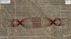
I have attached some examples of curved drone (and piloted aircraft) flight lines to provide a) a more diversity of view perspective and b) a way to mitigate the systematic Structure-from-Motion doming/dishing (elevation) error.
Attachments
-
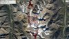 McCall Glacier TurnOutLoops Image.jpg1 MB · Views: 30
 -
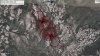 Peeble Creek Mine Second TEST 021819 Image.jpg1.1 MB · Views: 30
 -
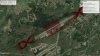 Bessemer Airport POINTS 021619.jpg962.8 KB · Views: 28
 -
 Chino Mine Site Mission Plan Image.jpg962.3 KB · Views: 27
 -
 NM TL Corridor State Plane Output 021919 Image.jpg1 MB · Views: 26
- Joined
- Jun 21, 2019
- Messages
- 2
- Reaction score
- 1
- Age
- 56

Similar threads
- Replies
- 11
- Views
- 4K
- Replies
- 5
- Views
- 1K
- Replies
- 17
- Views
- 2K
