

I did do a search on NFZ this time before I posted this question but didn't find the answer I was looking for. I thought I read somewhere that the Typhoon H had built in firmware that would not even allow it to be powered up if it was within ANY NFZ let alone restrict flying to a specified low level. Can someone describe what the real restrictions are and how the 'H' works with them? I apologize if this a repeat question from someone else but I didn't find one as I have read where some individuals seem to be very disturbed by 'newbee' questions being posted.
Be careful of the hearsay. What you are looking for is in section 5 and starts on page 80.
https://www.gpo.gov/fdsys/pkg/FR-2016-06-28/pdf/2016-15079.pdf
Synopsis: Local Air Traffic Control (ATC) authorizations are required for operation in Class B, C, D and when close to their lateral boundaries when within Class E. Class A is restricted by the 400ft altitude rule. Class G requires no clearance as well as E unless operating on the boundary of B,C or D.
Radius/Altitude: Subjective for specific airport see THIS MAP and search your local airport for specifics.
How to read aeronautical charts.
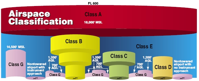
The H according to Yuneec (info is a little dated) enables a geofence around each airport which has controlled airspace (B, C, D) and restricts flight despite clearances a person may have from ATC. Last we heard these were all a 5miles radius from an airport's center except in Washington DC which has many more restrictions.
Yuneec has firmware available for the H920 and the Q500 to remove these restrictions but we are not sure about the H yet. Yuneec typically requires justification for the removal of restrictions but if you can prove you have authorization from your local ATC and/or sUAS certification from the FAA they should be able to help out.
To bypass the GPS: GPS is a very weak signal. To block it and subsequently disable the geofence it just needs to be covered with a small amount of metal. Taping a couple layers of tinfoil over where it says 'GPS' on the H should do the trick. The remote also has a GPS on it, not sure where but grab some tinfoil and experiment. DISCLAIMER: The drone will no longer auto hover in place and all 'Smart Mode' features will be disabled. Make sure you are a confident pilot before experimenting with this method.
Last edited:


") i
i