Hello everybody! Before anything I apologize for the (yet again) long post, but I think some context is needed.
Since I bought my Typhoon H I had only perfomed bench tests and one take off test at an empty parking lot. Yesterday I tried, for the first time, to make a proper flight test in an open area with a radius of around 110 metres, no metal structures or buildings nearby and a clear vision of the sky for GPS locking purposes.
After normal ST-16 and ACFT startup I received a no fly zone related warning which I dismissed (I'll explain why a bit further) and carried on with systems check and "READY" on GPS indication, then walked some 10 metres away from the ACFT and tried to engage the motors with the red button. I could hear an audible "deny-like" sign coming from the aircraft and no further response, no motor start. After a couple of times, I tried an automatic take off via the "task" option on the ST-16, also without success. After a few tries, I was getting out of daylight and decided to wrap everything up and go home. Already knowing that Yuneec's NFZs are huge, I went to their website to check it and, to my surprise, I realized that I couldn't fly almost anywhere in my city. This was a bit of a shock, since I had (as I always do) filed a flight plan with the Brazilian Airspace Control and I have all necessary clearances to fly a UAS. Also, I had flown several times in the same region with my DJI Mavic without any problem whatsoever, always with the proper clearances.
Below, there are some screenshots comparing the maps of the Brazilian Airspace Control, Yuneec and DJI regarding UAS operations, with brief explanations. In all of them, the solid red circle next to the red arrow covers a radius of roughly 110 metres in which I was allowed to fly up to 130 ft ASL, according to the filed flight plan.

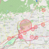
Official Brazilian Airspace Control map. This is the map used for all UAS flight planning and clearances, which uses their own dedicated system and data. The red translucent circles are restricted areas, where flights can be allowed under certain circumstances. Regardless of these areas, when flights are filed, the system automatically approves or denies them, accordingly to the parameters used (time of day, altitude, flight area and ACFT classification).

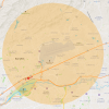
Yuneec's bizarre NFZ map. By this map, most of my city's airspace is a NFZ. The area is the same for any airport, regardless of its size. The puzzling fact is that I managed to take off, hover and land during the aforementioned motor test in a parking lot, which is also located inside Yuneec's NFZ, but much closer to the runway orientation. During this test no warning was given.

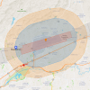
DJI's GEO Zone map. This is a MUCH better map, which takes into consideration the size of the airport, runway axis and arrival/departure paths. The orange area represents and Enhanced Warning Zone where users are required to unlock the flight promptly by agreeing with all responsibility for their actions. The blue area is an Authorization Zone, where flight can be unlocked in a similar way, but requires registration on DJI's website and following a specific procedure.
Given all this context, I would like to ask if anyone knows why the crap Yuneec's NFZs are even more stringent than my country's official airspace UAS regulations (which, by the way, are based on FAA's), and how do I get rid of this limitation, since it basically disallows any operation inside my urban area, rendering my Typhoon mostly useless for my work. I searched the forum for answers and noted that there lots of folks with the same problem. Also, trying to access Yuneec's NFZ release is useless, since the webpage is broken. The only one which works, seems to be for US users only.
Any help is greatly appreciated.
Since I bought my Typhoon H I had only perfomed bench tests and one take off test at an empty parking lot. Yesterday I tried, for the first time, to make a proper flight test in an open area with a radius of around 110 metres, no metal structures or buildings nearby and a clear vision of the sky for GPS locking purposes.
After normal ST-16 and ACFT startup I received a no fly zone related warning which I dismissed (I'll explain why a bit further) and carried on with systems check and "READY" on GPS indication, then walked some 10 metres away from the ACFT and tried to engage the motors with the red button. I could hear an audible "deny-like" sign coming from the aircraft and no further response, no motor start. After a couple of times, I tried an automatic take off via the "task" option on the ST-16, also without success. After a few tries, I was getting out of daylight and decided to wrap everything up and go home. Already knowing that Yuneec's NFZs are huge, I went to their website to check it and, to my surprise, I realized that I couldn't fly almost anywhere in my city. This was a bit of a shock, since I had (as I always do) filed a flight plan with the Brazilian Airspace Control and I have all necessary clearances to fly a UAS. Also, I had flown several times in the same region with my DJI Mavic without any problem whatsoever, always with the proper clearances.
Below, there are some screenshots comparing the maps of the Brazilian Airspace Control, Yuneec and DJI regarding UAS operations, with brief explanations. In all of them, the solid red circle next to the red arrow covers a radius of roughly 110 metres in which I was allowed to fly up to 130 ft ASL, according to the filed flight plan.

Official Brazilian Airspace Control map. This is the map used for all UAS flight planning and clearances, which uses their own dedicated system and data. The red translucent circles are restricted areas, where flights can be allowed under certain circumstances. Regardless of these areas, when flights are filed, the system automatically approves or denies them, accordingly to the parameters used (time of day, altitude, flight area and ACFT classification).

Yuneec's bizarre NFZ map. By this map, most of my city's airspace is a NFZ. The area is the same for any airport, regardless of its size. The puzzling fact is that I managed to take off, hover and land during the aforementioned motor test in a parking lot, which is also located inside Yuneec's NFZ, but much closer to the runway orientation. During this test no warning was given.

DJI's GEO Zone map. This is a MUCH better map, which takes into consideration the size of the airport, runway axis and arrival/departure paths. The orange area represents and Enhanced Warning Zone where users are required to unlock the flight promptly by agreeing with all responsibility for their actions. The blue area is an Authorization Zone, where flight can be unlocked in a similar way, but requires registration on DJI's website and following a specific procedure.
Given all this context, I would like to ask if anyone knows why the crap Yuneec's NFZs are even more stringent than my country's official airspace UAS regulations (which, by the way, are based on FAA's), and how do I get rid of this limitation, since it basically disallows any operation inside my urban area, rendering my Typhoon mostly useless for my work. I searched the forum for answers and noted that there lots of folks with the same problem. Also, trying to access Yuneec's NFZ release is useless, since the webpage is broken. The only one which works, seems to be for US users only.
Any help is greatly appreciated.


