Hello Fellow Yuneec Pilot!
Join our free Yuneec community and remove this annoying banner!
Sign up

BIG and frightening problem since last update

Joined
Dec 14, 2019
Messages
70
Reaction score
13
Age
44
Hi fellow H520 pilots!

Just a warning concerning the last big software update in Europe. Recently my yuneec H520 asked to do a major update of the updatepilot, remote control, datapilot, E90, flightcontrol and gimbal that all needed to be updated. All updates were executed and OK. All calibrations were done successfully.

Today I took the H520 then for a flight. Luckily, I did this on our model aircraft terrain as a MAJOR problem occurred.
  • context: All GPS signals, RSSI, battery status, temperature, KP, etc. were perfect at start-up. I checked if I can switch to manual mode after taking off: all controls worked perfectly. Monitoring during flight also showed no problem what so ever. No interferences as this is a model aircraft terrain. Prior I never had problems here. No other RPAS were flying today.
  • all of a sudden, I get an error mentioning that there is no more connection between the RC and the H520. The H520 is not controllable anymore, only at some very limited and intermittent moments a signal gets trough, but the H520 keeps executing the last command it received (e.g. full speed ahead). I finally managed to land the drone, but I was VERY lucky no one was flying, nor present at the time I flew today!! In the details I see the drone keeps switching between WiFi and analog and vice versa. Never had that prior to this last update. It also shows it enters in Failsafe mode, yet no control is possible... I don't get the notice 'home point updated' anymore either... I don't know what is the failsafe mode as it is not described in the manual (v1.6) of the H520... I suppose it is meant to do a RTH, yet it definitely did not do that! As you can see in the screenshots, this happened to me every time I flew. So, completely shutting down and restarting did not help, and it is clearly a structural problem as it didn't just occur once, but every time I was flying!
  • Besides that problem, also the camera is faulty since the update. You can start it for video, or trigger it for photos, but after you end the video or after 2-3 photos, the shutter button keeps spinning and none of the camera buttons react anymore...

Besides these two big problems, I also noticed that the region of interest is gone in de menu. Why? Please, this was a major advantage compared to DJI drones, and now it's gone... Yuneec should reactivate it again.

But the main issue is the problem (loss of RC and camera problem) described above. I can't understand how a company as Yuneec can issue a faulty update like that. If I would have been on a professional mission in a city centre, I would definitely have lost my H520 as it certainly would have crashed into a building or tree.

Just wanted to warn you all...
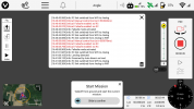
Screenshot_2021-01-24-16-41-35.png
 
Last edited:
There are two threads discussing this problem. A fix is expected from Yuneec. However you may find a way to solve your current problem by reading through these threads:
 
There are two threads discussing this problem. A fix is expected from Yuneec. However you may find a way to solve your current problem by reading through these threads:
Thanks Steve, but the first one (thread of vr-pilot) is only talking about some drift and gaining control again in ATTI (manual). The second one treats spinning of the camera as I understood. None of those apply to me. I lost complete RC connection, so it didn't react to the stick input, only randomly a bit... Camera stayed on. ATTI / Manual did nog resolve as the RC connection was down. I was lucky it happened near myself...

Anyone knows why it switches between WiFi and Analog and vice versa?
Anyone knows what the RPAS is supposed to do in failsafe mode?
 
Dear community,
Just an update as I think it's important for you all.
I have reset everything again, performed the updates again and then redone all the calibrations.
Today I tested everything again on our club and it all seems to work. OSB working. HEVC not working in video (so that didn't change)
So probably somewhere an error or bug must have occurred in during the first time I updated...
I'll retry in the next days and I'll keep you informed.
Cheers and fingers crossed for the next flights!
 
Last edited:
but yesterday new updates arrived... I hope these fixe all problems...
Keep us updated with your progress with the new update.
 
Simple test on my balcony after last update(
20210131_164658[1].jpg 20210131_164825[1].jpg
When i change flight mode from auto to manual - no problem. When i returned mode back to auto - it was not successfully.
I had these messages:
20210131_164938[1].jpg "Switching to this mode is currently not possible" and "horizontal GPS position error too high", "GPS speed accuracy too low", GPS vertical drift to high".
Also i saw notice "manual control lost". For the shot time .
20210131_170244[1].jpg
Strange situation( Not possible to fly.
How do you think, friends, does somebody from Yuneec company know about this problems?
 
Simple test on my balcony after last update(
View attachment 24629 View attachment 24630
When i change flight mode from auto to manual - no problem. When i returned mode back to auto - it was not successfully.
I had these messages:
View attachment 24631 "Switching to this mode is currently not possible" and "horizontal GPS position error too high", "GPS speed accuracy too low", GPS vertical drift to high".
Also i saw notice "manual control lost". For the shot time .
View attachment 24632
Strange situation( Not possible to fly.
How do you think, friends, does somebody from Yuneec company know about this problems?
You Need to go in open space to tight detection of GPS
 
You Need to go in open space to tight detection of GPS
Simple test on my balcony after last update(
Yes, 14 satellites should be enough, especially when GPS shows green. None the less;

Yesterday:
My only flight test of the newest upgrade did not behave that way. I had lots of satellites, and a green lock. But the errors did not clear until I moved to an area of wide open spaces. I made two very short flights after the messages cleared, and saw no issues. However, after landing from the second flight, one of the messages re-appeared. Even though there was nothing at all near by. There was little cloud cover, and full access to the sky in all directions.

Today:
I was prompted by your posts to do a similar test. I put the H520 in a fully enclosed patio. There were lots of metal objects nearby. There are lots of electrical circuits near. The area is fully enclosed, with NO clear access to the sky. The weather is fairly cold, a full overcast cloud cover of the sky, and occasional light snow. I repeated the test three times. The first two times, I got NO error messages at all. On the third test, I got one brief error message, which cleared itself within a few seconds. Changing flight modes did not result in any messages or warnings.

The testing today was using the same H520, same controller and the same battery as yesterday. Todays testing was done with a different E90 camera. The camera used for the flight test yesterday is no longer available to me.

I have heard only one comment indicating Yuneec is aware of the problem. The issuance of two additional revisions within a couple of days implies they are aware of the issue. As with many of us, I wish some statement would appear to clarify what Yuneec's thoughts are, what adjustments they may make available. At least make some revision notes available.

I do not have an opinion yet. These are just observations to add to yours, and others, as we try to develop some sort of understanding of this latest update.
 
  • Like
Reactions: vr-pilot
Mistake in EXIF metadata (wrong altitude). Real altitude over sea level 138 meters. In EXIF i see 182 meters. Camera E90. I made test 30 min ago.
 
  • Like
Reactions: vr-pilot
I just sent this mail to Yuneec after the last smaller update:

I would need two more clarifications:
  • Could you explain me what function do have the buttons T3 and T4 from the annex have? One of them is the zoom, yet T4 doesn't seem to do anything anymore. Formerly T3 was the big zoom steps, and T4 the small zoom steps.
  • when activation the geofence with the HOLD function, the drone gets stuck. Only way of getting him back is doing a RTL, yet I don't want that. Sometimes doing that is dangerous, and moreover, during a mission, I don't want to restart all over again. Can I change the HOLD setting to WARNING once it gets stuck (so during the flight)? Why can't the hold not just stop the drone at the boundary, but let me continue to fly? Is switching in the settings to WARNING going to work? That would be a work around, yet best would be if the HOLD function is just to hold the drone within the boundaries, not to force a RTL...
Besides these clarifications, I really do have an urgent request that should be very easy to implement as before it was implemented. Can you please return the function ROI? I really would need this function, which I used many times before. All of a sudden, this function is gone without notice, yet this was a major advantage of the H520 compared to other drones...

Is it possible that the connection range with the E90 is worse than before since the last updates? Yesterday I went for a fly, clear sky, no obstructions, yet I twice had an interruption of the camera during flight...

Also, I noticed that the height in the EXIF data of the E90 is wrong I get height indications of 170 to 210m, yet I never was above 120m (my geofence is set to 120m). It's not the difference between AMSL and AGV, as the GLV is at 49m. When flying at 120m I get an indication of 210m, so 90m (!) difference.


For me these are the main findings after two batteries yesterday in the open field...
Too bad Yuneec doesn't provide a log of the changes...
Thank you for your letter to Yuneec.
Only for information. Camera E50 also write wrong altitude in EXIF (-138 meters instead 138 meters). This fact was a reason why i started make updates. I updated E50 firmware, but it didn't help. Now i need upload coordinates of photos from the photogrammetry software in *.txt file, edit altitude and download this file back.
 

New Posts

Members online

Forum statistics

Threads
21,146
Messages
243,825
Members
27,823
Latest member
tzagge