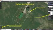
I recently tried a structure scan of a small barn as a test. I used DataPilot (latest version) on my laptop to program it, but had an issue with the "Entrance/Exit Alt" value (I entered 20m) not holding after saving and reverting to 0m, as well the entry point location changed after saving to a mission then re-opening.
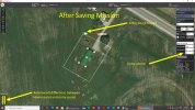
Before going to the actual site, I loaded the mission from my laptop to the ST16s and opened it, the "Entrance/Exit Alt" value was a “0” and the entry point was changed (as it was saved on the laptop).
When I went to the actual site (BTW all trees and other objects have since been removed from the earlier Google map view), I started up the H520, opened the mission on the ST16s then entered the 20m as the “Entrance/Exit Alt” and moved the entry point where I wanted it, but instead of saving the mission to the ST16s, I uploaded it to the H520 directly, and upon starting the mission, it executed it as I expected using the 20m “Entrance/Exit Alt” and the newly entered entrance point.
So, is this normal for DataPilot?