Hello Fellow Yuneec Pilot!
Join our free Yuneec community and remove this annoying banner!
Sign up

What Effects Would High Altitude Have on the Drone?

Joined
Oct 14, 2019
Messages
66
Reaction score
33
Age
48
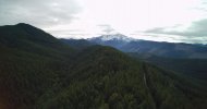
I was flying in the foothills leading up to Mount Rainier yesterday and launched the drone from an altitude of 3280 feet and went up 400 feet to 3680 feet. That's just a hair under 0.7 miles above Sea Level. The air should be thinner there but to be honest I can't say that I noticed anything different at all in the way the drone performed.

Was the altitude not really that much of a factor? How high above Sea Level does the drone have to be to start to be significantly affected by the thinner air? What performance factors are the most affected? Lift? Time to Climb? Stability? Handling? Flight Time?
 

Attachments

  • YUN00516.jpg
    YUN00516.jpg
    1.1 MB · Views: 20
Lift... certainly. Time to climb... maybe. Reduced flight time... absolutely, as the props have to spin faster to counteract that reduced lift, increasing battery draw to maintain a state of flight, whether climbing, hovering or descending.

Might be barely noticable at 3600 feet, but I have flight times in ABQ (at 5000 ASL) to 6000 feet in surrounding areas... generally get 5-7 minutes less, than many who fly closer to sea level.
 
I was at location just over 3800 feet earlier in the year, compared to a little less than 1000 where I usually fly. The H seemed quite sluggish, in both climb and forward flight.
 
Lift... certainly. Time to climb... maybe. Reduced flight time... absolutely, as the props have to spin faster to counteract that reduced lift, increasing battery draw to maintain a state of flight, whether climbing, hovering or descending.

Might be barely noticable at 3600 feet, but I have flight times in ABQ (at 5000 ASL) to 6000 feet in surrounding areas... generally get 5-7 minutes less, than many who fly closer to sea level.
This and be aware that the higher you go the more wind there will be.
 
These are your altitudes?! I hope you're not in the US...
The OP is discussing his altitude above sea level... not his aircraft's altitude above his launch point.
This and be aware that the higher you go the more wind there will be.
There is higher wind above ground level... this is not associated with the ASL.
 
  • Like
Reactions: chascoadmin
Go back into your flight training and read about density altitude. Temperature, besides altitude all play a role in aircraft performance.
I'm not sure about the H, but the book for my Q500 4K said to stay below 8000 ft MSL.
 
I know @Enrico Jorysch has flown the Typhoon H at altitudes over 8000’ (2440m). He may even have a spec sheet that gives the maximum operational altitude of the H480. A web search failed to find it since Yuneec abandoned all their old web files.
 
I know @Enrico Jorysch has flown the Typhoon H at altitudes over 8000’ (2440m). He may even have a spec sheet that gives the maximum operational altitude of the H480. A web search failed to find it since Yuneec abandoned all their old web files.
I haven't tried to search it, I know the Q500 4K above 8000' MSL is not recommended. That being said, a person, if they are concerned, should do their Density Altitude calculations, keeping in mind that ambient temperature plays a large part in that.
 
Those that used the 8000+ firmware for the Q500 usually used a carbon fiber prop with a more aggressive pitch.

One of Enrico’s flights with the Typhoon H.
 
Those that used the 8000+ firmware for the Q500 usually used a carbon fiber prop with a more aggressive pitch.

One of Enrico’s flights with the Typhoon H.
Very nice video. Acouple of places, it looked like he could have encountered some icing conditions, Increasing pitch angle is one way to compensate for thinner air.
 
  • Like
Reactions: DoomMeister
With the Typhoon H 4000 m above sea level is no problem...
but please do not fly in fog, if the temperature is below 4 degrees Celsius... Danger of icing.

With the Q500 2500 m above sea level are possible.
There is a firmware with which you can also fly higher, but I do not recommend it... the motors are too weak for that.

Gruss Enrico
 
Thanks Enrico! I knew you would have that information. Still love your video at the Matterhorn.

Is there a chance you have the specs saved for the H480 that included the maximum operational height MSL? I remember seeing it on one of the Yuneec websites, but all older information has been deleted from their domain.
 
With the Typhoon H 4000 m above sea level is no problem...
but please do not fly in fog, if the temperature is below 4 degrees Celsius... Danger of icing.

With the Q500 2500 m above sea level are possible.
There is a firmware with which you can also fly higher, but I do not recommend it... the motors are too weak for that.

Gruss Enrico
I would like to include clouds and for the same reason, icing. Clouds are moist air and are visable because the ambient temperature and the dew point are very close together.
 
Unfortunately, I no longer have any data sheets.... but I think that Yuneec has specified 4000m above sea level... without guarantee.

Greetings Enrico
 
Finding performance data for most consumer level sUAS is a problem, mostly I think, because most of the manufacturers consider them toys. if you want to get an idea of what altitude and temperature has on aircraft performance, do a search for a Cessna 150 or 172. The data will show you the effects on, for example, takeoff roll and rate of climb. That is also where density altitude comes into play. All aircraft performance, UAS or manned, is effected by altitude and temperature. Take, for example, the area where you normally fly, as temperature goes up, air density goes down, resulting in the aircraft performing as if it were at a higher altitude.
 

New Posts

Members online

Forum statistics

Threads
20,955
Messages
241,587
Members
27,284
Latest member
csandoval