

You are using an out of date browser. It may not display this or other websites correctly.
You should upgrade or use an alternative browser.
You should upgrade or use an alternative browser.
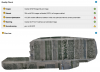
H 520 for mapping better than P4P?
- Thread starter FlyaDrone
- Start date
I'm not sure if DJI paid for this video, but it's deeply misleading. Some of the mistakes have been pointed out in the comments, but frankly they so completely void the test Drone U should take it down.
The P4P has exactly the same 'rolling shutter' effect as the E90 - it's not global. What the test doesn't mention is that the P4P and E90 have quite different fields of view. The guy did the two surveys at the same height, which means the E90 will have been capturing less detail, If he can't get basics like that right, his results are going to be all over the place. He's not posted ISO and exposure settings (so we have no idea if he was actually shooting under equivalent conditions). He talks nonsense about capturing golf courses that is just painful - the list goes on.
Mapping is not simple. We've had more than one pilot posting complete nonsense about 'how to map' and then declare themselves such an expert they can teach other people how to do it. In reality, all they have done is played with the point and click interface and uploaded to an online service that does all the work for them. They don't actually understand what they are doing, nor how to get better results. When things go wrong, they blame the camera, the drone - anything but their own lack of understanding.

- Joined
- Sep 29, 2017
- Messages
- 35
- Reaction score
- 2
- Age
- 71
This is far from the first time that he has been criticized for making comments that were less than accurate during one of his podcasts. I think the guy tries to hard to be an expert in too many areas. He sets a high bar for his own competence in that he attempts to create and in-depth podcast almost everyday and also has a subscription service that he and staff also populate for a fee paid access status to some of their more detailed tutorials. I am just glad that the internet population is able to offer contradictory comments that offer corrections for consideration.
The problem is, if this is his full time job, by now he should be an expert. If you look at Joshua Bardwell, who puts out a similar level of videos for the FPV scene, you see an in depth knowledge that's matched with some very thorough and scientific testing.
This guy though just talks nonsense, and doesn't issue anything that constitutes a proper correction when called out. The fact that a 'commercial expert' has videos on the Mavic Air and P4P as his two main drones speaks volumes.
This guy though just talks nonsense, and doesn't issue anything that constitutes a proper correction when called out. The fact that a 'commercial expert' has videos on the Mavic Air and P4P as his two main drones speaks volumes.
arruntus
Premium Pilot
- Joined
- Aug 19, 2017
- Messages
- 1,851
- Reaction score
- 730
A correction, the P4P has global shutter, the normal P4 is the one that does not. What he's saying is that sense, is right. For photogrammetry, not having a global shutter is a handicap.
About a hexacopter spinning out of control when losing an engine, I think it was misunderstood and referred to a quadicopter.
That it is necessary to have circular flights to make photogrammetry is also correct.
The fact that he doesn't give concrete data on the conditions for taking the images I also think it's a mistake.
In general terms to say that for photogrammetry a P4P is better than an H520 is correct. We shall see tomorrow, but today it is correct.
arruntus
Premium Pilot
- Joined
- Aug 19, 2017
- Messages
- 1,851
- Reaction score
- 730
@arruntus not true, P4P has the same sensor Sony EXMOR which has rolling readout, the only difference it has mechanical shutter release (which is not equal to global shutter in case of photogrammetry).
yes u are right but the mechanical shutter makes you not suffer from the effect the same way you would if you didn't have it. The difference is big.
From having nothing, to having it, is a big step forward

A correction, the P4P has global shutter, the normal P4 is the one that does not. What he's saying is that sense, is right. For photogrammetry, not having a global shutter is a handicap.
About a hexacopter spinning out of control when losing an engine, I think it was misunderstood and referred to a quadicopter.
That it is necessary to have circular flights to make photogrammetry is also correct.
The fact that he doesn't give concrete data on the conditions for taking the images I also think it's a mistake.
In general terms to say that for photogrammetry a P4P is better than an H520 is correct. We shall see tomorrow, but today it is correct.
You do not need circular flights for photogrammetry. In fact, there are techniques to get accurate measurements from photographs that are not even orthorectified.
- Joined
- Feb 11, 2018
- Messages
- 161
- Reaction score
- 71
- Age
- 46
You do not need circular flights for photogrammetry. In fact, there are techniques to get accurate measurements from photographs that are not even orthorectified
I agree its not required in many circumstances, but if you want to model vertical surfaces of a building, or want to map a tall thin structure like a mobile phone mast / cell tower then it becomes quite import.
Unless i've missed the general gist of your post, in that case examples would be appreciated.
arruntus
Premium Pilot
- Joined
- Aug 19, 2017
- Messages
- 1,851
- Reaction score
- 730
I agree its not required in many circumstances, but if you want to model vertical surfaces of a building, or want to map a tall thin structure like a mobile phone mast / cell tower then it becomes quite import.
Unless i've missed the general gist of your post, in that case examples would be appreciated.
Effectively, there are more things to do than photogrammetrically, and that is precisely why it is necessary.
- Joined
- Apr 29, 2018
- Messages
- 43
- Reaction score
- 15
- Age
- 59
You do not need circular flights for photogrammetry. In fact, there are techniques to get accurate measurements from photographs that are not even orthorectified.
It does depend on what you are mapping/modelling, if you are mapping cell phone towers, POI and circular flights are part of the profile. - not sure if that is what you are specifically referencing by circular flights. Another long term design issue would be to move the photo button to another location so you can yaw and take photos at the same time, especially if you are trying to create a circular flight path manually.
You can always set the camera to take photos every 2-3sec. This allows you to concentrate on positioning and flying and assures you get the best shot.It does depend on what you are mapping/modelling, if you are mapping cell phone towers, POI and circular flights are part of the profile. - not sure if that is what you are specifically referencing by circular flights. Another long term design issue would be to move the photo button to another location so you can yaw and take photos at the same time, especially if you are trying to create a circular flight path manually.
- Joined
- Apr 29, 2018
- Messages
- 43
- Reaction score
- 15
- Age
- 59
You can always set the camera to take photos every 2-3sec. This allows you to concentrate on positioning and flying and assures you get the best shot.
Have you ever done any cell phone tower mapping?
- Joined
- Feb 11, 2018
- Messages
- 161
- Reaction score
- 71
- Age
- 46
You can always set the camera to take photos every 2-3sec. This allows you to concentrate on positioning and flying and assures you get the best shot.
Whilst this can work, it's not really a good strategy when a client is paying. What you want is good data first time. Even with that there's benefits for taking a laptop with you and assuming you have Pix4D, running the data through the Rapid processing first step to check that all will calibrate.
It does depend on what you are mapping/modelling, if you are mapping cell phone towers, POI and circular flights are part of the profile. - not sure if that is what you are specifically referencing by circular flight
Sorry, yeah meant POI or multiple POI for cell towers. When I said what alternative techniques @Panomapic meant I was thinking along the lines of innovative survey flights.
For instance I've read an OpenDroneMap developer say that running 2 single grids at different altitudes helps to reduce parallax errors. Also seen that the Altizure app for DJI will prompt you to do 4 additional single grids, each offset by 50% towards the cardinal points, with the camera/gimbal pointed towards the centre of the original grid. If you fly all 5 grids then the result is a lot of images, but potentially a lot of 3D data including vertical faces.
Thsat saidI've yet to try these techniques! Hope to soon as workload settles.
- Joined
- Apr 29, 2018
- Messages
- 43
- Reaction score
- 15
- Age
- 59
Whilst this can work, it's not really a good strategy when a client is paying. What you want is good data first time. Even with that there's benefits for taking a laptop with you and assuming you have Pix4D, running the data through the Rapid processing first step to check that all will calibrate.
Sorry, yeah meant POI or multiple POI for cell towers. When I said what alternative techniques @Panomapic meant I was thinking along the lines of innovative survey flights.
For instance I've read an OpenDroneMap developer say that running 2 single grids at different altitudes helps to reduce parallax errors. Also seen that the Altizure app for DJI will prompt you to do 4 additional single grids, each offset by 50% towards the cardinal points, with the camera/gimbal pointed towards the centre of the original grid. If you fly all 5 grids then the result is a lot of images, but potentially a lot of 3D data including vertical faces.
Thsat saidI've yet to try these techniques! Hope to soon as workload settles.
You are very observant, for the mapping we are doing the client has a profile that specifies not to use timed shots, but to shoot manually as they are getting better results that way (using POI) as with the wind the machine will vary in its actual speed around the structure, taking photos manually you can adjust the speed of shooting. Without POI, it gets much harder.....
While there's an active discussion about the E90, rolling shutters, and mapping (and use of Pix4D) I have a question to toss out there for those of you with more experience with RBG cameras (and Pix4D).
BTW, It was news to me that the E90 has a rolling shutter - I've found it difficult to find details about this camera, especially when the details might lead me to forming a less favorable opinion of the camera.
Is poor image geolocation inevitable with a rolling shutter?
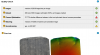
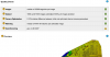
So, I've started re-doing orthomosaic images in Pix4D that were obtained using the E90 and editing the camera parameters to account for the rolling shutter. However, I'm still finding pretty unsatisfactory camera optimization differences according to the Quality Reports produced in Pix4D. For example, for one set of test plots, Pix4D calculated a 113% difference between initial and optimized internal camera parameters (prior to my accounting for the rolling shutter) see "WCRC" report snips attached. Now that I know about the rolling shutter, I'm still getting optimization differences of 30-60% (e.g., "GJMA" snips). Basically, Pix4D recommends a complete re-analysis if the optimization differences are >20% (which is what I did for the GJMA image, inserting the optimized camera parameters from the first analysis as initial values for the re-analysis - and still I obtained >27% differences - albeit, a large improvement over the initial 91% differences).
I was oblivious to this issue since I've been happily building vegetation maps using my RedEdge camera (with a global shutter) and observing <1% differences between initial and optimized parameters (e.g., "AT" snips).
Any insights from the many of you with expertise are greatly appreciated.
Thanks, RichA
BTW, It was news to me that the E90 has a rolling shutter - I've found it difficult to find details about this camera, especially when the details might lead me to forming a less favorable opinion of the camera.
Is poor image geolocation inevitable with a rolling shutter?
So, I've started re-doing orthomosaic images in Pix4D that were obtained using the E90 and editing the camera parameters to account for the rolling shutter. However, I'm still finding pretty unsatisfactory camera optimization differences according to the Quality Reports produced in Pix4D. For example, for one set of test plots, Pix4D calculated a 113% difference between initial and optimized internal camera parameters (prior to my accounting for the rolling shutter) see "WCRC" report snips attached. Now that I know about the rolling shutter, I'm still getting optimization differences of 30-60% (e.g., "GJMA" snips). Basically, Pix4D recommends a complete re-analysis if the optimization differences are >20% (which is what I did for the GJMA image, inserting the optimized camera parameters from the first analysis as initial values for the re-analysis - and still I obtained >27% differences - albeit, a large improvement over the initial 91% differences).
I was oblivious to this issue since I've been happily building vegetation maps using my RedEdge camera (with a global shutter) and observing <1% differences between initial and optimized parameters (e.g., "AT" snips).
Any insights from the many of you with expertise are greatly appreciated.
Thanks, RichA
Attachments
arruntus
Premium Pilot
- Joined
- Aug 19, 2017
- Messages
- 1,851
- Reaction score
- 730
While there's an active discussion about the E90, rolling shutters, and mapping (and use of Pix4D) I have a question to toss out there for those of you with more experience with RBG cameras (and Pix4D).
BTW, It was news to me that the E90 has a rolling shutter - I've found it difficult to find details about this camera, especially when the details might lead me to forming a less favorable opinion of the camera.
Is poor image geolocation inevitable with a rolling shutter?
So, I've started re-doing orthomosaic images in Pix4D that were obtained using the E90 and editing the camera parameters to account for the rolling shutter. However, I'm still finding pretty unsatisfactory camera optimization differences according to the Quality Reports produced in Pix4D. For example, for one set of test plots, Pix4D calculated a 113% difference between initial and optimized internal camera parameters (prior to my accounting for the rolling shutter) see "WCRC" report snips attached. Now that I know about the rolling shutter, I'm still getting optimization differences of 30-60% (e.g., "GJMA" snips). Basically, Pix4D recommends a complete re-analysis if the optimization differences are >20% (which is what I did for the GJMA image, inserting the optimized camera parameters from the first analysis as initial values for the re-analysis - and still I obtained >27% differences - albeit, a large improvement over the initial 91% differences).
I was oblivious to this issue since I've been happily building vegetation maps using my RedEdge camera (with a global shutter) and observing <1% differences between initial and optimized parameters (e.g., "AT" snips).
Any insights from the many of you with expertise are greatly appreciated.
Thanks, RichA
Metadata accuracy problem for E90 + Pix4D?
I have watched a few of Drone U´s videos and from my viewpoint they are all DJI ads.
Similar threads
- Replies
- 2
- Views
- 2K
- Replies
- 4
- Views
- 2K
- Replies
- 37
- Views
- 8K
