Hello Fellow Yuneec Pilot!
Join our free Yuneec community and remove this annoying banner!
Sign up

Lose mantis q/lost connection with drone and motor error

I cannot detect what is in '/Log' because the file names are cut. But I think this is not relevant here. Please forget.

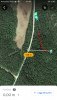
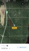
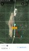
Distance of the last known position from start: 26,7m
Track length: ~65m
Last known position: 63°57'12.6"N 20°22'12.2"E

I'm now better to analyze the FlyLogs. Here are corrected CSV file and improved KML file (without gap):
 

Attachments

  • FlyLog_2020_04_17_14_15_49kml.zip
    86.9 KB · Views: 3
Ohh, this maybe also interesting:
Postion when 'Disarmed by abnormal motor.' message was raised:

I think this is the position where it hits the tree. After crash the GPS data may be inaccurate. This is not unusual. The relative altitude in this moment was 3,49m.

br HE
 
Last edited:
Ohh, this maybe also interesting:
Postion when 'Disarmed by abnormal motor.' message was raised:

I think this is the position where it hits the tree. After crash the GPS data may be inaccurate. This is not unusual. The relative altitude in this moment was 3,49m.

br HE

That was the point where i start Flying the drone. I maybe send you wrong file. Because I have check on my computer and got more info and another last position.

Those pictures I send now are those I get from the last trip when I lose my drone.
 

Attachments

  • 1DEF1E78-95D4-4D8E-AE4E-9E188931D7A7.jpeg
    1DEF1E78-95D4-4D8E-AE4E-9E188931D7A7.jpeg
    298 KB · Views: 7
  • 1BF96E74-21A9-45F3-8F6B-AF925F147446.jpeg
    1BF96E74-21A9-45F3-8F6B-AF925F147446.jpeg
    305.9 KB · Views: 6
  • FB4B4ABA-EFD1-47C0-B953-BF4A82888343.jpeg
    FB4B4ABA-EFD1-47C0-B953-BF4A82888343.jpeg
    326.6 KB · Views: 6
I will go in to my computer and send you the right one. I thing the file I send you before was not the file when I lose the drone. I need help with founding last position, high, speed, and other stuff that may help me to finde it. I’m going out later today for search with some friends
 
I think it is the right file because the low battery warning and the motor error is in. I do not know what the pictures from you app shows but the coordinates in the log file looking plausible. I do not know if Google Maps is always right.

Here is the position from Motor error in OpenStreetMap:
MotorErrorPostion_OSM.png

At this time:
- Voltage is low: 10,78V
- Altitude: 3,49m
- Speed: 2,44m/s
- Descend (z-speed): -1,49m/s
- Heading: 353°

br HE
 
I think it is the right file because the low battery warning and the motor error is in. I do not know what the pictures from you app shows but the coordinates in the log file looking plausible. I do not know if Google Maps is always right.

Here is the position from Motor error in OpenStreetMap:
View attachment 21447

At this time:
- Voltage is low: 10,78V
- Altitude: 3,49m
- Speed: 2,44m/s
- Descend (z-speed): -1,49m/s
- Heading: 353°

br HE


I know that this is the wrong file. Because I was not flying in that place the last flight: And I can verified that. What’s the program you use to se all that ? And the map you look at right now was amazing
 
I use q500log2kml to analyze Yuneec flight logs.

But the published version is not able to work with the FlyLog files from Mantis Q. I missed the MAVlink message GPS_RAW_INT.

Up to yesterday I did only know the log files that I have described above (Sensor_.... or Yuneec_....).Yesterday night and today I made a version that can read the MAVlink messages GLOBAL_POSITION_INT and BATTERY_STATUS.
This works now but is not fully tested thus not released to public.

If you want, you can send me the other log file. I will check it. It is also good test for me if all works well.

br HE
 
@Flackco,

It might actually help if you could zip all the files in the Flylog folder and post them here for @h-elsner. Then give him the date and time of the flight when you lost the Mantis Q. It would also help him fine tune the free program he offers for reading Yuneec’s telemetry on most every aircraft they make.
 
I use q500log2kml to analyze Yuneec flight logs.

But the published version is not able to work with the FlyLog files from Mantis Q. I missed the MAVlink message GPS_RAW_INT.

Up to yesterday I did only know the log files that I have described above (Sensor_.... or Yuneec_....).Yesterday night and today I made a version that can read the MAVlink messages GLOBAL_POSITION_INT and BATTERY_STATUS.
This works now but is not fully tested thus not released to public.

If you want, you can send me the other log file. I will check it. It is also good test for me if all works well.

br HE


hi, I dont know why the last flght got 0kb... and in the phone i can see that it got data.. but in the computer is like that file got nothing.

04/17-14:15 and 14:19 are those i need to see but the flight 2020-04-17 time 14:19 Pm is the last before i lose the drone..
 

Attachments

  • FlyLog_2020_04_17_10_07_21.zip
    186 bytes · Views: 2
  • FlyLog_2020_04_17_13_53_44.zip
    25.7 KB · Views: 2
  • FlyLog_2020_04_17_14_14_19.zip
    107.6 KB · Views: 2
  • FlyLog_2020_04_17_14_02_35.zip
    186 bytes · Views: 2
  • FlyLog_2020_04_17_13_55_43.zip
    530.9 KB · Views: 2
  • FlyLog_2020_04_17_14_15_49.zip
    90.3 KB · Views: 2
  • FlyLog_2020_04_17_14_19_37.zip
    186 bytes · Views: 2
i think this one was the last file
 

Attachments

  • YuneecFlyRecord_2020_04_25_21_24_17.zip
    15.6 KB · Views: 3
What phone do you have? iOS or Android?
Maybe the file is still open, not finalized. In this case it will copy nothing --> 0 byte file.
For me this file is empty, nothing to see...

A cold start of the phone may result to close the file and there is something in or the file will disappear at all. This is the worst case. Can you try to copy this file"FlyLog_2020_04_17_14_19_37" as second file with another name inside the file system of the phone?

br HE

Edit: OK, I see it is iOS 13.4.

Last position in the KMZ file:
 
Last edited:
What phone do you have? iOS or Android?
Maybe the file is still open, not finalized. In this case it will copy nothing --> 0 byte file.
For me this file is empty, nothing to see...

A cold start of the phone may result to close the file and there is something in or the file will disappear at all. This is the worst case. Can you try to copy this file"FlyLog_2020_04_17_14_19_37" as second file with another name inside the file system of the phone?

br HE

Edit: OK, I see it is iOS 13.4.

Last position in the KMZ file:


You want me Change the name of the file ?

Yes that’s the right place. And I need to see high, speed and other stuff.
 
You want me Change the name of the file ?
I'm thinking about a way to recover th 0-byte file. If you think this is the richt flight log file it would be nice to have something in.

Yes that’s the right place. And I need to see high, speed and other stuff.
This is from the KMZ file. There are only some information in, not enough for proper analysis but possibly good for searching.


StartTime>2020-04-17 14:19:37 +0200
HomeLongitude>20.369960
HomeLatitude>63.953458
Duration>139

Last coordinate and hight (time, lon, lat, alt)
2020-04-17 14:21:56 +0200, 20.372469, 63.951569, 84.871193m​


Chart_altitude_01.pngChart_distance_01.png

This is a chart from altitude and asecond that shows the distance to start position computed from coordinates.

I can try to find the speed from coordinates and time stamps but this needs a new application for computing. Lets see how fast I can do that.

br HE
 
Last edited:
This is all what I could grab from the KMZ file. Computed values Ground and vertical speed are not exact because the time not exact enough (only fulle seconds).

br HE
 

Attachments

  • YuneecFlyRecord_2020_04_25_21_24_17_data.zip
    86.2 KB · Views: 4
This is all what I could grab from the KMZ file. Computed values Ground and vertical speed are not exact because the time not exact enough (only fulle seconds).

br HE

Okej. Can you copy here the result of the file ? I can’t see them
 
I need help to open the last file you send me. I need to send it to them( The seller , they ask about it) but I can’t open it.
 
Yes, here are some messages that I could filter out from the log file:

D:\Flight_Log_data\MantisQ\FlyLog_2020_04_17_14_15_49__Flackco\FlyLog_2020_04_17_14_15_49
7 00:03:25 CRITICAL: 'vehicle command 176 (1 4 2 0)'
8 00:03:25 INFO: '(3,11)TAKEOFF MODE'
14 00:03:25 INFO: 'Takeoff detected.'
146 00:03:28 INFO: '(3,16) Current range distance data is valid'
190 00:03:28 CRITICAL: 'State: 10 to 2 for stick movement'
864 00:03:39 INFO: '(3,17) Current range distance data is invalid'
1107 00:03:43 CRITICAL: 'State: 2 to 14 for mode_slot changed'
1108 00:03:43 INFO: '(3,25)SPORT MODE'
1530 00:03:50 CRITICAL: '(2,29) LOW BATTERY, RETURN TO LAUNCH ADVISED.'
2887 00:04:12 INFO: '(3,16) Current range distance data is valid'
2930 00:04:12 INFO: '(3,17) Current range distance data is invalid'
3049 00:04:14 INFO: '(3,16) Current range distance data is valid'
3396 00:04:20 CRITICAL: '(2,29) LOW BATTERY, RETURN TO LAUNCH ADVISED.'
3435 00:04:21 INFO: '(3,17) Current range distance data is invalid'
3550 00:04:22 INFO: 'Disarmed by abnormal motor.'
3552 00:04:22 CRITICAL: '(1,61)MOTOR 3 ERROR IS 4'

The *.kml file is for GoogleEarth to see and replay the flight track.
Or what file do you mean?

br HE
Okej. Thanks.
they asked me for the flightloggo. They want to see what happens before I lose the drone. And I remember that before I lose it I got motor error. But also press “turn home” but the drone never come back.
I don’t know how they gonna resolve it but I hope here in Sweden the seller pay me back..

why is not any information about the “ turn home “ when I did press it?
 
What phone do you have? iOS or Android?
Maybe the file is still open, not finalized. In this case it will copy nothing --> 0 byte file.
For me this file is empty, nothing to see...

A cold start of the phone may result to close the file and there is something in or the file will disappear at all. This is the worst case. Can you try to copy this file"FlyLog_2020_04_17_14_19_37" as second file with another name inside the file system of the phone?

br HE

Edit: OK, I see it is iOS 13.4.

Last position in the KMZ file:
How can I do the second file? I don’t know much about this.
Can you tell me the steps ? And I will try it.
Because the last file is the one I need most. But it’s empty and don’t know why.
 

New Posts

Members online

Forum statistics

Threads
20,954
Messages
241,586
Members
27,284
Latest member
csandoval