The operative phrase here is experiencing an issue -- GPS is designed to HELP keep the aircraft stabilized - as is the accelerometer - so yes, when you're in danger of a flyaway, taking over manual control can help you steer her back to you - despite wind, magnetic interference, intermittent conditions possilby - a battery fault such as a quicker than normal discharging, or loss of a motor, bird hit of a prop - you can always flip GPS back on - and see if you're stabilized again - you might also want to speed up or slow down the control wheel to be able to fly your way out of the area or have more subtle control over the sticks.Just a quick question about GPS related fly away. Should you shut off GPS mode if experiencing an issue once you notice erratic behaviors, then try and land?


You are using an out of date browser. It may not display this or other websites correctly.
You should upgrade or use an alternative browser.
You should upgrade or use an alternative browser.

DCH
Dr. FrankenPhoon
Truth be told, your writing style is not easy to understand in any of your posts. I am having difficulty interpreting what you are trying to tell us and it is very confusing.You are totally mis-interpreting what I had previously and currently written.

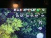
right - but the first one, this one is GPS on the Plus- how could I have any satellite connection if the Plus flew away still showing?- and where is the ground control satellites - I had 17 next to between 11 and 14 satellites to the Plus!
well at least I'm 100% consistent as you say nothing is clear .lol. I began flying after a perfect pre-flgiht. I flew for about 10 minutes - the bird began flying away from me at about 250 feet altitude and 500 feet distance - that's when the sticks became useless, WIFI appeared error on screen, and telemetry changed to no bird, nothing but what the screenshots show.Truth be told, your writing style is not easy to understand in any of your posts. I am having difficulty interpreting what you are trying to tell us and it is very confusing.
to your point "With no telemetry info showing on the controller and no WiFi signals displayed after binding". This is not the case at all. I bound the camera and bird without any issues and had full telemetry showing across the board, before flying. The screenshots were taken after the flyaway and some praying, searching and too much time elapsing to still hope for a re-connect.
Fact is you were flying in a very congested area full of interference in a Zero altitude NFZ. I'm surprised you were able to take off at all. How did you get the motors to start in this location?

this area is a forest and over 5 miles from LGA.Fact is you were flying in a very congested area full of interference in a Zero altitude NFZ. I'm surprised you were able to take off at all. How did you get the motors to start in this location?
View attachment 18055View attachment 18055
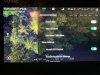
This is a rough estimate of the flight path. The last recorded location of the aircraft is at the top. The street level shot is close to the take off point looking in the direction of the line of flight.


- Joined
- Jul 4, 2017
- Messages
- 4,258
- Reaction score
- 2,026
Lots of interference may have caused the flyaway.
Hey @Steve Carr, if the H+ looses it's home base, will it auto land somewhere?
Hey @Steve Carr, if the H+ looses it's home base, will it auto land somewhere?
DCH
Dr. FrankenPhoon
Don't mean to but in for Steve, I believe it will do an emergency landing when the battery gets to the critical stage, even if already returning home. I saw a YouTube of just such a case with an H520 on it's way back with a low battery. It dropped the gear and descended into a field of spinach. He used another H to find it. The orange body popped against the green background making easy to spot. ...Good thing it didn't go down in a field of pumpkins!if the H+ looses it's home base, will it auto land somewhere?

I calibrated the compass facing north, and flew for about 5 minutes at low altitude watching to see how the GPS and Manual Mode were working, testing throwing the Manual Mode switch off almost immediately, and seeing if GPS either was working or might kick in if it wasn't working because of Manual Mode take-off. I was concerned switching off Manual Mode while airborne might cut the motors, which I tested on the ground with the motors running, switching off Manual Mode caused the motors to quit while on the ground. In the air, switching off Manual Mode did not shut off the motors. So along with my Visual Observer, I continued flying around 20 feet in the air for a few more minutes and felt I had control of the Plus. As I ascended to 200 feet approximately, I stayed within 200 - 300 feet distance - the trees in the forest are about 95 above ground level. I had VLOS at all times. When the bird started going North on its own, and lost WIFI, lost the video feed, lost the stick control, I couldn't pull her back so I flipped the RTL switch and waited - now the bird was not visible and I had no way of going into angle mode with any idea of heading, altitude or anything else. The forest drops down into a valley about 500 feet away, so there is better VLOS as you go North, but I lost VLOS as the flyaway progressed.So you were flying in a forest??? did you always have VLOS?
- Joined
- Jul 4, 2017
- Messages
- 4,258
- Reaction score
- 2,026
I guess that wasn't your "lucky" day? sorry for the pun and misfortune.
Don't know if you want to start hiking through the dense forest and open pastures finding your bird, but it may be worth a try?
Just bring your machete, you know those snakes, alligators and pesky varmints that run around can be quite entertaining.?
Like these plants that shoot poison darts. ? just kidding.
Last edited:
I guess that wasn't your "lucky" day? sorry for the pun and misfortune.
Don't know if you want to start hiking through the dense forest and open pastures finding your bird, but it may be worth a try?
Just bring your machete, you know those snakes, alligators and pesky varmints that run around can be quite entertaining.?
Like these plants that shoot poison darts. ? just kidding.
View attachment 18059
[/QUOTEThanks
Thanks for the kind words!! I am processing the misfortune by doing what I know to do - keep tracking with prayer and logistics. I left the house at 5:45am and took a bus to the basic area - hoofed into a lake area and realized I had to go north of the highways and I was was still south. Walked for 2 hours and got to the spot - you're right - in the deep woods, fortunately only mild bug attacks - but the swampy area would let me see the area I got right on top of the GPS longitude/latitude - the greenery was from 7 to 12 foot high, like huge corn stalks - I pushed them aside for awhile until I got too close to sinking into the swampy soft mud. I also searched nearby up in the trees to between the bushes - as the GPS may have quit and the Plus kept going - but no luck this time around. I took a lot of photos and videos of my journey, and once back out of the bushland, got back to the highway and treated myself to an Uber back home - I'm really not in 20 year old Marine combat shape at this stage but I was really hoping to come back home with my baby.I guess that wasn't your "lucky" day? sorry for the pun and misfortune.
Don't know if you want to start hiking through the dense forest and open pastures finding your bird, but it may be worth a try?
Just bring your machete, you know those snakes, alligators and pesky varmints that run around can be quite entertaining.?
Like these plants that shoot poison darts. ? just kidding.
View attachment 18059
The telemetry indicates:
There were sufficient satellites on both the Plus and the ST16.
You were flying in Manual Mode so the GPS was not being used.
As you increased altitude the wind increased. At 100m the wind speed was about 15 mph from the SW. The flight path indicates the H was moving with the wind to the NE.
Near the end of the record the ST16 was changed to Home, but in Manual mode this does not work.
The aircraft responded to the stick input throughout the flight.
The telemetry was still recording data when the ST16 was switched off.
Conclusion:
This was not a flyaway. The aircraft simply drifted away with the wind. It was still controllable but the pilot lost orientation and visual sight. When the controller was switched off the battery was at 15.6v at an altitude of 73m (239').
Wind at time of flight:
Thank you Steve - what you point out is exactly how the flight seemed to go from my perspective too. This then means that when you switch into Manual Mode, and take off, that switching Manual Mode off doesn't work once the flight has begun, as I was wary to fly in Manual Mode when I saw the initial amount of drifting in the first 5 mnutes or more - so I switched Manual Mode off and confirmed that Aircraft GPS switch remained on. You're saying I never got out of Manual Mode so that's good to know. Any idea why RTL didn't work since I did switch it off Manual Mode? Any idea why I lost the visual at such a short distance? Magnetic and other interference? Even now, the ST16s controller is still showing aircraft satellites connected, while indoors, and no ground control satellites both indoors (which is to be expected) but also still can't see any satellites to the ground control when outdoors either. Here are pictures from the final coordinates GPS I shot this morning, and the ST16s pictures I just took so show the indoor connection to aircraft satellites - 4 and no connection to ground control satellites. Thanks for your incredible attention to detail and efforts to clarify what happened!!The telemetry indicates:
There were sufficient satellites on both the Plus and the ST16.
You were flying in Manual Mode so the GPS was not being used.
As you increased altitude the wind increased. At 100m the wind speed was about 15 mph from the SW. The flight path indicates the H was moving with the wind to the NE.
Near the end of the record the ST16 was changed to Home, but in Manual mode this does not work.
The aircraft responded to the stick input throughout the flight.
The telemetry was still recording data when the ST16 was switched off.
Conclusion:
This was not a flyaway. The aircraft simply drifted away with the wind. It was still controllable but the pilot lost orientation and visual sight. When the controller was switched off the battery was at 15.6v at an altitude of 73m (239').
Wind at time of flight:
View attachment 18065
Attachments


Last edited:
I'm am not certain if the switching Manual mode off while in the air will work. I seem to recall you can turn it on and off after the Plus is flying, but if you turn on Manual while on the ground it will not turn on in the air.I switched Manual Mode off and confirmed that Aircraft GPS switch remained on.
Conjested areas with trees, power lines and home wifi's create a hostile environment for the H wifi video signal. Many people install the 4Hawks antenna to boost the signal strength.Any idea why I lost the visual at such a short distance?
Look at the controller more closely. You are seeing the sats connected to the ST16, not the Plus. There is a tiny icon for the ST16 and an sort of arrow for the Plus.the ST16s controller is still showing aircraft satellites connected,
I had it reversed!!! I always saw satellites show on the 2nd icon right away, so I thought because I turn on the ST16s first, that meant the first one was for the Plus as they always took time to populate after I powered up the Plus. What a mistake!!!! Thanks for pointing that out and the other tips! I checked the manual again and sure enough the icons show that the first has the small controller symbol and the second the arrow you mentioned - these old eyes not seeing smaller detail better these days sometimes. I couldn't find anything in the manual about changing to Manual mode off once in the air, so have to figure it cannot be altered after takeoff - I mean it can physically be changed on screen, but apparently has no affect on restoring GPS or RTL functions once Manual was selected.I'm am not certain if the switching Manual mode off while in the air will work. I seem to recall you can turn it on and off after the Plus is flying, but if you turn on Manual while on the ground it will not turn on in the air.
Conjested areas with trees, power lines and home wifi's create a hostile environment for the H wifi video signal. Many people install the 4Hawks antenna to boost the signal strength.
Look at the controller more closely. You are seeing the sats connected to the ST16, not the Plus. There is a tiny icon for the ST16 and an sort of arrow for the Plus.
Technically speaking, for consistency of software, the voltage readings then should be controller first, Plus second. Why wouldn't you follow the pattern of the workflow - each first icon is the controller, each 2nd icon icon for similar function would be for the Plus. (Satellites, voltage, etc). The icons for battery voltage on the Plus ST16s controller are reversed to Plus voltage first, then controller voltage 2nd.
Similar threads
- Replies
- 8
- Views
- 242
- Replies
- 0
- Views
- 677
- Replies
- 19
- Views
- 3K
- Replies
- 17
- Views
- 2K
